Santa Bárbara geodata
Santa Bárbara (Hidalgo) is a populated place; located in Mexico in America/Mexico_City (GMT-6) time zone. With population of 1,763 people, there are 4924 cities with bigger population in this country. Compared to other cities in Mexico, 50.5% of cities are located further ↑North; 56.4% of cities are located further ←West and 92.6% of cities have lower elevation than Santa Bárbara. Note1


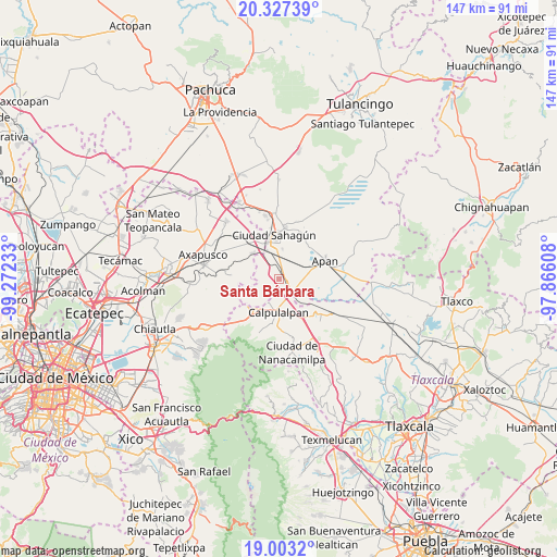
Santa Bárbara GPS coordinates[2]
19° 39' 59.976" North, 98° 34' 9.12" West
| Map corner | latitude | longitude |
|---|---|---|
| Upper-left | 20.32739°, | -99.27233° |
| Center: | 19.66666°, | -98.5692° |
| Lower-right: | 19.0032°, | -97.86608° |
| Map W x H: | 147.2×147.2 km | = 91.5×91.5mi |
| max Lat: | 32.7° ⇑50.5% North |
| Santa Bárbara: | 19.66666° |
| min Lat: | ⇓49.5% South 14.53588° |
| min Long | Santa Bárbara | max Long |
| -117.105° | -98.5692° | -86.73105° |
| W 56.4%⇐ | ⇒43.6% E |
Elevation
Elevation of Santa Bárbara is 2510 m = 8235 ft, and this is 1256.3 m = 4122 ft above average elevation for this country.
| Max E: |
3497 m = 11473 ft | 7.4% |
| Santa Bárbara | 2510 m 8235 ft | |
| Avg. | 1253.7 m = 4113 ft | |
Min E: |
-1 m = -3 ft | 92.6% |
See also: Mexico elevation on elevation.city.
Geographical zone
Santa Bárbara is located in North Torrid zone (between Equator and Tropic of Cancer). Distance of this Northern Tropic circle is 419.2 km =260.5 mi to North.| Distance of | km | miles | from Santa Bárbara |
|---|---|---|---|
| North Pole | 7820.3 | 4859.3 | to North |
| Arctic Circle | 5214.4 | 3240.1 | to North |
| Tropic Cancer | 419.2 | 260.5 | to North |
| Equator | 2186.7 | 1358.8 | to South |


Nearby cities:
15 places around Santa Bárbara: (largest is in red/bold)
• Acopinalco
6.1 km =3.8 mi,  38°
38°
• Calpulalpan
8.7 km =5.4 mi,  180°
180°
• Chimalpa y Tlalayote
6 km =3.7 mi,  91°
91°
• Emiliano Zapata
2.9 km =1.8 mi,  117°
117°
• Irolo
8.1 km =5 mi,  339°
339°
• Jaltepec
9.8 km =6.1 mi,  315°
315°
• José María Morelos (San José)
1.9 km =1.2 mi, 336°
• La Laguna
10.5 km =6.5 mi, 43°
• Los Voladores
8 km =5 mi,  78°
78°
• Lázaro Cárdenas
10.6 km =6.6 mi,  106°
106°
• San Bartolomé Tepetates
8.3 km =5.2 mi,  7°
7°
• San Felipe Sultepec
9.7 km =6 mi,  209°
209°
• San Marcos Guaquilpan
9.8 km =6.1 mi,  219°
219°
• Santa Clara
3.7 km =2.3 mi,  345°
345°
• Zotoluca
8.7 km =5.4 mi,  135°
135°
Sources, notices
• [Note1] Compared only with cities in Mexico existing in our database
• [Src1] Map data: © OpenStreetMap contributors (CC-BY-SA)
• [Src2] Other city data from geonames.org with taken over terms of usage.
• [Src3] Geographical zone / Annual Mean Temperature by Robert A. Rohde @ Wikipedia
