Mazapa geodata
Mazapa (Tlaxcala) is a populated place; located in Mexico in America/Mexico_City (GMT-6) time zone. With population of 1,972 people, there are 4420 cities with bigger population in this country. Compared to other cities in Mexico, 53.3% of cities are located further ↑North; 56.5% of cities are located further ←West and 97.5% of cities have lower elevation than Mazapa. Note1


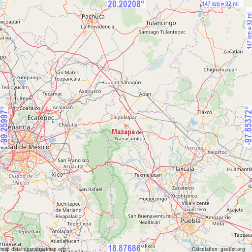
Mazapa GPS coordinates[2]
19° 32' 26.988" North, 98° 33' 24.624" West
| Map corner | latitude | longitude |
|---|---|---|
| Upper-left | 20.20208°, | -99.25997° |
| Center: | 19.54083°, | -98.55684° |
| Lower-right: | 18.87686°, | -97.85372° |
| Map W x H: | 147.4×147.4 km | = 91.6×91.6mi |
| max Lat: | 32.7° ⇑53.3% North |
| Mazapa: | 19.54083° |
| min Lat: | ⇓46.7% South 14.53588° |
| min Long | Mazapa | max Long |
| -117.105° | -98.55684° | -86.73105° |
| W 56.5%⇐ | ⇒43.5% E |
Elevation
Elevation of Mazapa is 2716 m = 8911 ft, and this is 1462.3 m = 4798 ft above average elevation for this country.
| Max E: |
3497 m = 11473 ft | 2.5% |
| Mazapa | 2716 m 8911 ft | |
| Avg. | 1253.7 m = 4113 ft | |
Min E: |
-1 m = -3 ft | 97.5% |
See also: Mexico elevation on elevation.city.
Geographical zone
Mazapa is located in North Torrid zone (between Equator and Tropic of Cancer). Distance of this Northern Tropic circle is 433.2 km =269.2 mi to North.| Distance of | km | miles | from Mazapa |
|---|---|---|---|
| North Pole | 7834.3 | 4868 | to North |
| Arctic Circle | 5228.4 | 3248.8 | to North |
| Tropic Cancer | 433.2 | 269.2 | to North |
| Equator | 2172.7 | 1350.1 | to South |


Nearby cities:
15 places around Mazapa: (largest is in red/bold)
• Calpulalpan
5.5 km =3.4 mi,  345°
345°
• Ciudad de Nanacamilpa
5.7 km =3.5 mi,  158°
158°
• Domingo Arenas (La Calera)
9 km =5.6 mi,  107°
107°
• Emiliano Zapata
12.7 km =7.9 mi,  5°
5°
• Francisco I. Madero
7.3 km =4.5 mi, 107°
• Francisco Villa
11.1 km =6.9 mi,  62°
62°
• La Soledad
6.4 km =4 mi,  267°
267°
• San Cristobal
11.4 km =7.1 mi,  285°
285°
• San Felipe Hidalgo
8.1 km =5 mi,  181°
181°
• San Felipe Sultepec
8.3 km =5.2 mi,  312°
312°
• San Marcos Guaquilpan
9.9 km =6.2 mi, 310°
• Sanctórum
10.4 km =6.5 mi,  120°
120°
• Santa Cruz Moxolahuac
10.4 km =6.5 mi,  173°
173°
• Santiago Cuaula
11.8 km =7.3 mi,  304°
304°
• Zotoluca
9.1 km =5.7 mi,  31°
31°
Sources, notices
• [Note1] Compared only with cities in Mexico existing in our database
• [Src1] Map data: © OpenStreetMap contributors (CC-BY-SA)
• [Src2] Other city data from geonames.org with taken over terms of usage.
• [Src3] Geographical zone / Annual Mean Temperature by Robert A. Rohde @ Wikipedia
