Texcala geodata
Texcala (Puebla) is a populated place; located in Mexico in America/Mexico_City (GMT-6) time zone. With population of 1,328 people, there are 6541 cities with bigger population in this country. Compared to other cities in Mexico, 73.9% of cities are located further ↑North; 70.1% of cities are located further ←West and 57.8% of cities have lower elevation than Texcala. Note1


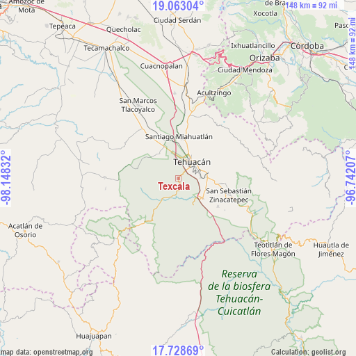
Texcala GPS coordinates[2]
18° 23' 49.776" North, 97° 26' 42.684" West
| Map corner | latitude | longitude |
|---|---|---|
| Upper-left | 19.06304°, | -98.14832° |
| Center: | 18.39716°, | -97.44519° |
| Lower-right: | 17.72869°, | -96.74207° |
| Map W x H: | 148.4×148.4 km | = 92.2×92.2mi |
| max Lat: | 32.7° ⇑73.9% North |
| Texcala: | 18.39716° |
| min Lat: | ⇓26.1% South 14.53588° |
| min Long | Texcala | max Long |
| -117.105° | -97.44519° | -86.73105° |
| W 70.1%⇐ | ⇒29.9% E |
Elevation
Elevation of Texcala is 1686 m = 5531 ft, and this is 432.3 m = 1418 ft above average elevation for this country.
| Max E: |
3497 m = 11473 ft | 42.2% |
| Texcala | 1686 m 5531 ft | |
| Avg. | 1253.7 m = 4113 ft | |
Min E: |
-1 m = -3 ft | 57.8% |
See also: Mexico elevation on elevation.city.
Geographical zone
Texcala is located in North Torrid zone (between Equator and Tropic of Cancer). Distance of this Northern Tropic circle is 560.3 km =348.2 mi to North.| Distance of | km | miles | from Texcala |
|---|---|---|---|
| North Pole | 7961.5 | 4947 | to North |
| Arctic Circle | 5355.6 | 3327.8 | to North |
| Tropic Cancer | 560.3 | 348.2 | to North |
| Equator | 2045.6 | 1271.1 | to South |


Nearby cities:
15 places around Texcala: (largest is in red/bold)
• Altepexi
15.6 km =9.7 mi,  100°
100°
• Francisco Ignacio Madero
10.8 km =6.7 mi,  349°
349°
• Necoxtla
9 km =5.6 mi,  89°
89°
• San Gabriel Chilac
13 km =8.1 mi,  127°
127°
• San Isidro Vista Hermosa
13 km =8.1 mi,  21°
21°
• San José Monte Chiquito
11 km =6.8 mi,  3°
3°
• San Juan Atzingo
12.6 km =7.8 mi,  150°
150°
• San Miguel
12.3 km =7.6 mi,  82°
82°
• Santa Cruz Acapa
12.6 km =7.8 mi, 85°
• Tehuacán
9 km =5.6 mi,  34°
34°
• Teloxtoc
14.4 km =8.9 mi,  262°
262°
• Teontepec
13.8 km =8.6 mi,  319°
319°
• Tepetzingo
11.7 km =7.3 mi, 76°
• Villa Alegría
14.9 km =9.3 mi,  9°
9°
• Zapotitlán
8.1 km =5 mi,  202°
202°
Sources, notices
• [Note1] Compared only with cities in Mexico existing in our database
• [Src1] Map data: © OpenStreetMap contributors (CC-BY-SA)
• [Src2] Other city data from geonames.org with taken over terms of usage.
• [Src3] Geographical zone / Annual Mean Temperature by Robert A. Rohde @ Wikipedia
