Necoxtla geodata
Necoxtla (Puebla) is a populated place; located in Mexico in America/Mexico_City (GMT-6) time zone. With population of 2,399 people, there are 3679 cities with bigger population in this country. Compared to other cities in Mexico, 73.8% of cities are located further ↑North; 70.9% of cities are located further ←West and 50% of cities have lower elevation than Necoxtla. Note1


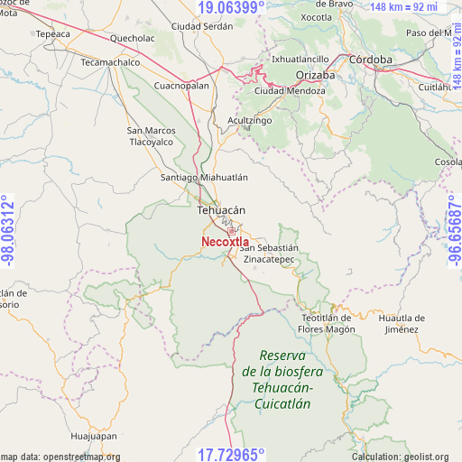
Necoxtla GPS coordinates[2]
18° 23' 53.196" North, 97° 21' 35.964" West
| Map corner | latitude | longitude |
|---|---|---|
| Upper-left | 19.06399°, | -98.06312° |
| Center: | 18.39811°, | -97.35999° |
| Lower-right: | 17.72965°, | -96.65687° |
| Map W x H: | 148.4×148.4 km | = 92.2×92.2mi |
| max Lat: | 32.7° ⇑73.8% North |
| Necoxtla: | 18.39811° |
| min Lat: | ⇓26.2% South 14.53588° |
| min Long | Necoxtla | max Long |
| -117.105° | -97.35999° | -86.73105° |
| W 70.9%⇐ | ⇒29.1% E |
Elevation
Elevation of Necoxtla is 1430 m = 4692 ft, and this is 176.3 m = 578 ft above average elevation for this country.
| Max E: |
3497 m = 11473 ft | 50% |
| Necoxtla | 1430 m 4692 ft | |
| Avg. | 1253.7 m = 4113 ft | |
Min E: |
-1 m = -3 ft | 50% |
See also: Mexico elevation on elevation.city.
Geographical zone
Necoxtla is located in North Torrid zone (between Equator and Tropic of Cancer). Distance of this Northern Tropic circle is 560.2 km =348.1 mi to North.| Distance of | km | miles | from Necoxtla |
|---|---|---|---|
| North Pole | 7961.4 | 4947 | to North |
| Arctic Circle | 5355.5 | 3327.8 | to North |
| Tropic Cancer | 560.2 | 348.1 | to North |
| Equator | 2045.7 | 1271.1 | to South |


Nearby cities:
15 places around Necoxtla: (largest is in red/bold)
• Ajalpan
10.9 km =6.8 mi,  101°
101°
• Altepexi
7.1 km =4.4 mi,  115°
115°
• Cinco de Mayo
9.8 km =6.1 mi,  80°
80°
• Necoxcalco
9.5 km =5.9 mi,  42°
42°
• San Gabriel Chilac
8.1 km =5 mi,  170°
170°
• San Isidro Vista Hermosa
12.7 km =7.9 mi,  340°
340°
• San José Buena Vista
9.7 km =6 mi,  85°
85°
• San José Monte Chiquito
13.7 km =8.5 mi,  322°
322°
• San Juan Atzingo
11.4 km =7.1 mi,  194°
194°
• San Mateo Tlacoxcalco
12.9 km =8 mi,  164°
164°
• San Miguel
3.5 km =2.2 mi,  63°
63°
• Santa Cruz Acapa
3.7 km =2.3 mi, 76°
• Tehuacán
8.3 km =5.2 mi,  331°
331°
• Tepetzingo
3.5 km =2.2 mi, 41°
• Texcala
9 km =5.6 mi,  269°
269°
Sources, notices
• [Note1] Compared only with cities in Mexico existing in our database
• [Src1] Map data: © OpenStreetMap contributors (CC-BY-SA)
• [Src2] Other city data from geonames.org with taken over terms of usage.
• [Src3] Geographical zone / Annual Mean Temperature by Robert A. Rohde @ Wikipedia
