Tepetzingo geodata
Tepetzingo (Puebla) is a populated place; located in Mexico in America/Mexico_City (GMT-6) time zone. With population of 1,970 people, there are 4425 cities with bigger population in this country. Compared to other cities in Mexico, 73.5% of cities are located further ↑North; 71.2% of cities are located further ←West and 50.5% of cities have higher elevation than Tepetzingo. Note1


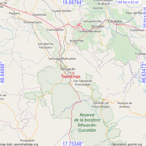
Tepetzingo GPS coordinates[2]
18° 25' 18.66" North, 97° 20' 16.26" West
| Map corner | latitude | longitude |
|---|---|---|
| Upper-left | 19.08764°, | -98.04098° |
| Center: | 18.42185°, | -97.33785° |
| Lower-right: | 17.75348°, | -96.63473° |
| Map W x H: | 148.3×148.3 km | = 92.1×92.1mi |
| max Lat: | 32.7° ⇑73.5% North |
| Tepetzingo: | 18.42185° |
| min Lat: | ⇓26.5% South 14.53588° |
| min Long | Tepetzingo | max Long |
| -117.105° | -97.33785° | -86.73105° |
| W 71.2%⇐ | ⇒28.8% E |
Elevation
Elevation of Tepetzingo is 1401 m = 4596 ft, and this is 147.3 m = 483 ft above average elevation for this country.
| Max E: |
3497 m = 11473 ft | 50.5% |
| Tepetzingo | 1401 m 4596 ft | |
| Avg. | 1253.7 m = 4113 ft | |
Min E: |
-1 m = -3 ft | 49.5% |
See also: Mexico elevation on elevation.city.
Geographical zone
Tepetzingo is located in North Torrid zone (between Equator and Tropic of Cancer). Distance of this Northern Tropic circle is 557.6 km =346.5 mi to North.| Distance of | km | miles | from Tepetzingo |
|---|---|---|---|
| North Pole | 7958.7 | 4945.3 | to North |
| Arctic Circle | 5352.9 | 3326.1 | to North |
| Tropic Cancer | 557.6 | 346.5 | to North |
| Equator | 2048.3 | 1272.8 | to South |


Nearby cities:
15 places around Tepetzingo: (largest is in red/bold)
• Ajalpan
9.6 km =6 mi,  119°
119°
• Altepexi
7 km =4.3 mi,  144°
144°
• Cinco de Mayo
7.4 km =4.6 mi,  98°
98°
• Necoxcalco
6 km =3.7 mi,  43°
43°
• Necoxtla
3.5 km =2.2 mi,  221°
221°
• San Antonio Cañada
11.4 km =7.1 mi,  23°
23°
• San Gabriel Chilac
10.7 km =6.6 mi,  185°
185°
• San Isidro Vista Hermosa
11.4 km =7.1 mi,  324°
324°
• San José Buena Vista
7.6 km =4.7 mi, 104°
• San José Monte Chiquito
13.4 km =8.3 mi,  307°
307°
• San Miguel
1.3 km =0.8 mi, 141°
• Santa Cruz Acapa
2.2 km =1.4 mi,  145°
145°
• Tehuacán
7.8 km =4.8 mi, 306°
• Texcala
11.7 km =7.3 mi,  256°
256°
• Zinacatepec
13.7 km =8.5 mi,  134°
134°
Sources, notices
• [Note1] Compared only with cities in Mexico existing in our database
• [Src1] Map data: © OpenStreetMap contributors (CC-BY-SA)
• [Src2] Other city data from geonames.org with taken over terms of usage.
• [Src3] Geographical zone / Annual Mean Temperature by Robert A. Rohde @ Wikipedia
