La Resurrección geodata
La Resurrección (Puebla) is a populated place; located in Mexico in America/Mexico_City (GMT-6) time zone. With population of 9,065 people, there are 1042 cities with bigger population in this country. Compared to other cities in Mexico, 63% of cities are located further ↑North; 62.2% of cities are located further ←West and 88.1% of cities have lower elevation than La Resurrección. Note1


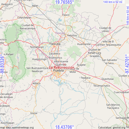
La Resurrección GPS coordinates[2]
19° 6' 10.044" North, 98° 7' 48.468" West
| Map corner | latitude | longitude |
|---|---|---|
| Upper-left | 19.76585°, | -98.83326° |
| Center: | 19.10279°, | -98.13013° |
| Lower-right: | 18.43706°, | -97.42701° |
| Map W x H: | 147.7×147.7 km | = 91.8×91.8mi |
| max Lat: | 32.7° ⇑63% North |
| La Resurrección: | 19.10279° |
| min Lat: | ⇓37% South 14.53588° |
| min Long | La Resurrecció | max Long |
| -117.105° | -98.13013° | -86.73105° |
| W 62.2%⇐ | ⇒37.8% E |
Elevation
Elevation of La Resurrección is 2346 m = 7697 ft, and this is 1092.3 m = 3584 ft above average elevation for this country.
| Max E: |
3497 m = 11473 ft | 11.9% |
| La Resurrección | 2346 m 7697 ft | |
| Avg. | 1253.7 m = 4113 ft | |
Min E: |
-1 m = -3 ft | 88.1% |
See also: Mexico elevation on elevation.city.
Geographical zone
La Resurrección is located in North Torrid zone (between Equator and Tropic of Cancer). Distance of this Northern Tropic circle is 481.9 km =299.4 mi to North.| Distance of | km | miles | from La Resurrección |
|---|---|---|---|
| North Pole | 7883 | 4898.3 | to North |
| Arctic Circle | 5277.1 | 3279 | to North |
| Tropic Cancer | 481.9 | 299.4 | to North |
| Equator | 2124 | 1319.8 | to South |


Nearby cities:
15 places around La Resurrección: (largest is in red/bold)
• 6 de Junio
2 km =1.2 mi,  294°
294°
• Casa Blanca
6.8 km =4.2 mi,  170°
170°
• Concepción Capulac (La Ex-Hacienda)
7.3 km =4.5 mi,  97°
97°
• Ignacio Zaragoza
9.3 km =5.8 mi,  126°
126°
• Primero de Mayo
4.1 km =2.5 mi,  124°
124°
• San Isidro Buen Suceso
6.4 km =4 mi,  24°
24°
• San Jacinto
8.5 km =5.3 mi, 128°
• San Martin
8.4 km =5.2 mi,  152°
152°
• San Miguel Canoa
6.2 km =3.9 mi,  27°
27°
• San Miguel Espejo
6.7 km =4.2 mi, 97°
• San Sebastián de Aparicio
3.2 km =2 mi,  271°
271°
• Santa María Xonacatepec
3.2 km =2 mi, 118°
• Signoret
6.5 km =4 mi,  141°
141°
• Tenancingo
9 km =5.6 mi,  303°
303°
• Villa Vicente Guerrero
4.3 km =2.7 mi, 298°
Sources, notices
• [Note1] Compared only with cities in Mexico existing in our database
• [Src1] Map data: © OpenStreetMap contributors (CC-BY-SA)
• [Src2] Other city data from geonames.org with taken over terms of usage.
• [Src3] Geographical zone / Annual Mean Temperature by Robert A. Rohde @ Wikipedia
