Puerto Arista geodata
Puerto Arista (Chiapas) is a populated place; located in Mexico in America/Mexico_City (GMT-6) time zone. With population of 944 people, there are 9225 cities with bigger population in this country. Compared to other cities in Mexico, 97.5% of cities are located further ↑North; 86% of cities are located further ←West and 97.5% of cities have higher elevation than Puerto Arista. Note1


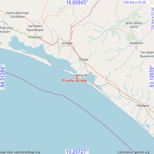
Puerto Arista GPS coordinates[2]
15° 56' 4.2" North, 93° 48' 34.956" West
| Map corner | latitude | longitude |
|---|---|---|
| Upper-left | 16.60945°, | -94.51284° |
| Center: | 15.9345°, | -93.80971° |
| Lower-right: | 15.25727°, | -93.10659° |
| Map W x H: | 150.3×150.4 km | = 93.4×93.5mi |
| max Lat: | 32.7° ⇑97.5% North |
| Puerto Arista: | 15.9345° |
| min Lat: | ⇓2.5% South 14.53588° |
| min Long | Puerto Arista | max Long |
| -117.105° | -93.80971° | -86.73105° |
| W 86%⇐ | ⇒14% E |
Elevation
Elevation of Puerto Arista is 9 m = 30 ft, and this is 1244.7 m = 4084 ft below average elevation for this country.
| Max E: |
3497 m = 11473 ft | 97.5% |
| Avg. | 1253.7 m = 4113 ft | |
| Puerto Arista | 9 m = 30 ft | |
Min E: |
-1 m = -3 ft | 2.5% |
See also: Mexico elevation on elevation.city.
Geographical zone
Puerto Arista is located in North Torrid zone (between Equator and Tropic of Cancer). Distance of this Northern Tropic circle is 834.2 km =518.3 mi to North.| Distance of | km | miles | from Puerto Arista |
|---|---|---|---|
| North Pole | 8235.3 | 5117.2 | to North |
| Arctic Circle | 5629.4 | 3497.9 | to North |
| Tropic Cancer | 834.2 | 518.3 | to North |
| Equator | 1771.8 | 1100.9 | to South |


Nearby cities:
15 places around Puerto Arista: (largest is in red/bold)
• Cabeza de Toro
2.9 km =1.8 mi,  84°
84°
• Doctor Belisario Domínguez (La Barra)
12.4 km =7.7 mi,  113°
113°
• El Congreso
13 km =8.1 mi,  9°
9°
• Huizachal
13.1 km =8.1 mi,  4°
4°
• Josefa Ortiz de Domínguez (La Esmeralda)
11.4 km =7.1 mi,  54°
54°
• La Laguna
7.5 km =4.7 mi, 2°
• La Polka
15.8 km =9.8 mi, 80°
• Llano Largo
9.8 km =6.1 mi, 8°
• Miguel Hidalgo Número Dos (Veinte de Noviembre)
1.9 km =1.2 mi,  359°
359°
• Noyola
12.5 km =7.8 mi,  21°
21°
• Paredón
14.3 km =8.9 mi,  334°
334°
• San Luqueño
9.5 km =5.9 mi,  336°
336°
• San Nicolás
13.8 km =8.6 mi, 0°
• Vicente Guerrero
9.9 km =6.2 mi,  41°
41°
• Villahermosa
9.2 km =5.7 mi,  353°
353°
Sources, notices
• [Note1] Compared only with cities in Mexico existing in our database
• [Src1] Map data: © OpenStreetMap contributors (CC-BY-SA)
• [Src2] Other city data from geonames.org with taken over terms of usage.
• [Src3] Geographical zone / Annual Mean Temperature by Robert A. Rohde @ Wikipedia
