Puebla geodata
Puebla is a seat of a first-order administrative division; located in Mexico in America/Mexico_City (GMT-6) time zone. With population of 1,434,062 people, there are 4 cities with bigger population in this country. Compared to other cities in Mexico, 64.1% of cities are located further ↑North; 61.1% of cities are located further ←West and 80.1% of cities have lower elevation than Puebla. Note1


Puebla GPS coordinates[2]
19° 2' 16.548" North, 98° 12' 12.456" West
| Map corner | latitude | longitude |
|---|---|---|
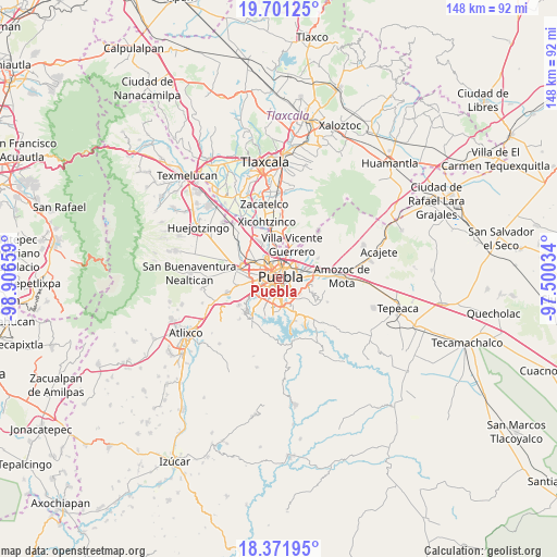
| Upper-left | 19.70125°, | -98.90659° |
| Center: | 19.03793°, | -98.20346° |
| Lower-right: | 18.37195°, | -97.50034° |
| Map W x H: | 147.8×147.8 km | = 91.8×91.8mi |
| max Lat: | 32.7° ⇑64.1% North |
| Puebla: | 19.03793° |
| min Lat: | ⇓35.9% South 14.53588° |
| min Long | Puebla | max Long |
| -117.105° | -98.20346° | -86.73105° |
| W 61.1%⇐ | ⇒38.9% E |
Elevation
Elevation of Puebla is 2143 m = 7031 ft, and this is 889.3 m = 2918 ft above average elevation for this country.
| Max E: |
3497 m = 11473 ft | 19.9% |
| Puebla | 2143 m 7031 ft | |
| Avg. | 1253.7 m = 4113 ft | |
Min E: |
-1 m = -3 ft | 80.1% |
See also: Puebla elevation on elevation.city.
Geographical zone
Puebla is located in North Torrid zone (between Equator and Tropic of Cancer). Distance of this Northern Tropic circle is 489.1 km =303.9 mi to North.| Distance of | km | miles | from Puebla |
|---|---|---|---|
| North Pole | 7890.2 | 4902.7 | to North |
| Arctic Circle | 5284.4 | 3283.6 | to North |
| Tropic Cancer | 489.1 | 303.9 | to North |
| Equator | 2116.8 | 1315.3 | to South |


Nearby cities:
15 places around Puebla: (largest is in red/bold)
• 18 de Marzo
8.9 km =5.5 mi,  149°
149°
• 6 de Junio
10 km =6.2 mi,  36°
36°
• Artículo Primero Constitucional
8.5 km =5.3 mi, 146°
• Casa Blanca
8.9 km =5.5 mi,  86°
86°
• Cuautlancingo
9.3 km =5.8 mi,  308°
308°
• Galaxia la Calera
6.9 km =4.3 mi,  128°
128°
• La Trinidad Chautenco
8.6 km =5.3 mi, 312°
• Resurgimiento Atotonilco
9.6 km =6 mi,  181°
181°
• San Andrés Cholula
9.8 km =6.1 mi,  278°
278°
• San Bernardino Tlaxcalancingo
7.8 km =4.8 mi,  262°
262°
• San Juan Tepepa
8.8 km =5.5 mi,  144°
144°
• San Sebastián de Aparicio
8.5 km =5.3 mi,  31°
31°
• Sanctorum
8.6 km =5.3 mi,  321°
321°
• Santiago Momoxpan
7.8 km =4.8 mi,  300°
300°
• Santo Tomás Chautla
9.6 km =6 mi, 146°
In other languages:
- In Spanish: Puebla de Zaragoza, Puebla, Heróica Puebla de Zaragoza
- In Russian: Пуэбла-де-Сарагоса
- In Chinese: 普埃布拉
Sources, notices
• [Note1] Compared only with cities in Mexico existing in our database
• [Src1] Map data: © OpenStreetMap contributors (CC-BY-SA)
• [Src2] Other city data from geonames.org with taken over terms of usage.
• [Src3] Geographical zone / Annual Mean Temperature by Robert A. Rohde @ Wikipedia
