Potrerillo geodata
Potrerillo (Chiapas) is a populated place; located in Mexico in America/Mexico_City (GMT-6) time zone. With population of 2,062 people, there are 4231 cities with bigger population in this country. Compared to other cities in Mexico, 98.3% of cities are located further ↑North; 95.2% of cities are located further ←West and 64.5% of cities have higher elevation than Potrerillo. Note1


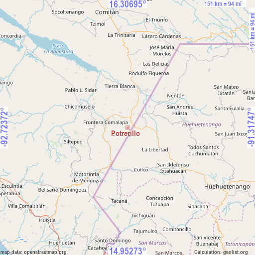
Potrerillo GPS coordinates[2]
15° 37' 51.456" North, 92° 1' 14.124" West
| Map corner | latitude | longitude |
|---|---|---|
| Upper-left | 16.30695°, | -92.72372° |
| Center: | 15.63096°, | -92.02059° |
| Lower-right: | 14.95273°, | -91.31747° |
| Map W x H: | 150.6×150.6 km | = 93.6×93.6mi |
| max Lat: | 32.7° ⇑98.3% North |
| Potrerillo: | 15.63096° |
| min Lat: | ⇓1.7% South 14.53588° |
| min Long | Potrerillo | max Long |
| -117.105° | -92.02059° | -86.73105° |
| W 95.2%⇐ | ⇒4.8% E |
Elevation
Elevation of Potrerillo is 717 m = 2352 ft, and this is 536.7 m = 1761 ft below average elevation for this country.
| Max E: |
3497 m = 11473 ft | 64.5% |
| Avg. | 1253.7 m = 4113 ft | |
| Potrerillo | 717 m = 2352 ft | |
Min E: |
-1 m = -3 ft | 35.5% |
See also: Mexico elevation on elevation.city.
Geographical zone
Potrerillo is located in North Torrid zone (between Equator and Tropic of Cancer). Distance of this Northern Tropic circle is 867.9 km =539.3 mi to North.| Distance of | km | miles | from Potrerillo |
|---|---|---|---|
| North Pole | 8269.1 | 5138.2 | to North |
| Arctic Circle | 5663.2 | 3518.9 | to North |
| Tropic Cancer | 867.9 | 539.3 | to North |
| Equator | 1738 | 1079.9 | to South |


Nearby cities:
15 places around Potrerillo: (largest is in red/bold)
• Agua Zarca
13.3 km =8.3 mi,  271°
271°
• Ciudad Cuauhtémoc
4.3 km =2.7 mi,  24°
24°
• El Anonal
13.2 km =8.2 mi,  298°
298°
• El Pacayal
4.3 km =2.7 mi,  213°
213°
• El Portal
9.6 km =6 mi, 302°
• Guadalupe Victoria
5.3 km =3.3 mi,  239°
239°
• La Lima
12.2 km =7.6 mi,  287°
287°
• Monte Redondo
4 km =2.5 mi,  306°
306°
• Nuevo México
10.7 km =6.6 mi, 305°
• Pacayalito
8.7 km =5.4 mi, 243°
• Paso Hondo
5.9 km =3.7 mi,  2°
2°
• Sabinalito
8.7 km =5.4 mi, 24°
• Santa Rita
6.2 km =3.9 mi,  338°
338°
• Veinte de Noviembre
9.8 km =6.1 mi,  219°
219°
• Verapaz
10 km =6.2 mi,  333°
333°
Sources, notices
• [Note1] Compared only with cities in Mexico existing in our database
• [Src1] Map data: © OpenStreetMap contributors (CC-BY-SA)
• [Src2] Other city data from geonames.org with taken over terms of usage.
• [Src3] Geographical zone / Annual Mean Temperature by Robert A. Rohde @ Wikipedia
