Nuevo México geodata
Nuevo México (Chiapas) is a populated place; located in Mexico in America/Mexico_City (GMT-6) time zone. With population of 678 people, there are 12811 cities with bigger population in this country. Compared to other cities in Mexico, 98.2% of cities are located further ↑North; 94.8% of cities are located further ←West and 64.5% of cities have higher elevation than Nuevo México. Note1


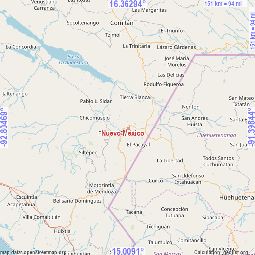
Nuevo México GPS coordinates[2]
15° 41' 13.704" North, 92° 6' 5.616" West
| Map corner | latitude | longitude |
|---|---|---|
| Upper-left | 16.36294°, | -92.80469° |
| Center: | 15.68714°, | -92.10156° |
| Lower-right: | 15.0091°, | -91.39844° |
| Map W x H: | 150.5×150.5 km | = 93.5×93.5mi |
| max Lat: | 32.7° ⇑98.2% North |
| Nuevo México: | 15.68714° |
| min Lat: | ⇓1.8% South 14.53588° |
| min Long | Nuevo México | max Long |
| -117.105° | -92.10156° | -86.73105° |
| W 94.8%⇐ | ⇒5.2% E |
Elevation
Elevation of Nuevo México is 716 m = 2349 ft, and this is 537.7 m = 1764 ft below average elevation for this country.
| Max E: |
3497 m = 11473 ft | 64.5% |
| Avg. | 1253.7 m = 4113 ft | |
| Nuevo México | 716 m = 2349 ft | |
Min E: |
-1 m = -3 ft | 35.5% |
See also: Mexico elevation on elevation.city.
Geographical zone
Nuevo México is located in North Torrid zone (between Equator and Tropic of Cancer). Distance of this Northern Tropic circle is 861.7 km =535.4 mi to North.| Distance of | km | miles | from Nuevo México |
|---|---|---|---|
| North Pole | 8262.8 | 5134.3 | to North |
| Arctic Circle | 5656.9 | 3515 | to North |
| Tropic Cancer | 861.7 | 535.4 | to North |
| Equator | 1744.2 | 1083.8 | to South |


Nearby cities:
15 places around Nuevo México: (largest is in red/bold)
• Agua Zarca
7.5 km =4.7 mi,  218°
218°
• Bellavista del Norte
6.5 km =4 mi,  249°
249°
• Comalapa
5.4 km =3.4 mi,  234°
234°
• Costa Rica
8.8 km =5.5 mi,  324°
324°
• El Anonal
3 km =1.9 mi,  271°
271°
• El Portal
1.3 km =0.8 mi,  151°
151°
• El Triunfo de las Tres Maravillas
7.4 km =4.6 mi, 232°
• Guadalupe Grijalva
6.8 km =4.2 mi,  281°
281°
• La Lima
3.9 km =2.4 mi, 229°
• La Sabinada
5.5 km =3.4 mi, 275°
• Monte Redondo
6.7 km =4.2 mi,  125°
125°
• Paso Hondo
8.9 km =5.5 mi,  92°
92°
• Santa Rita
6.4 km =4 mi, 94°
• Santa Rosa
4.1 km =2.5 mi,  356°
356°
• Verapaz
5 km =3.1 mi,  57°
57°
Sources, notices
• [Note1] Compared only with cities in Mexico existing in our database
• [Src1] Map data: © OpenStreetMap contributors (CC-BY-SA)
• [Src2] Other city data from geonames.org with taken over terms of usage.
• [Src3] Geographical zone / Annual Mean Temperature by Robert A. Rohde @ Wikipedia
