Veinte de Noviembre geodata
Veinte de Noviembre (Chiapas) is a populated place; located in Mexico in America/Mexico_City (GMT-6) time zone. With population of 954 people, there are 9131 cities with bigger population in this country. Compared to other cities in Mexico, 98.4% of cities are located further ↑North; 94.9% of cities are located further ←West and 59.8% of cities have higher elevation than Veinte de Noviembre. Note1


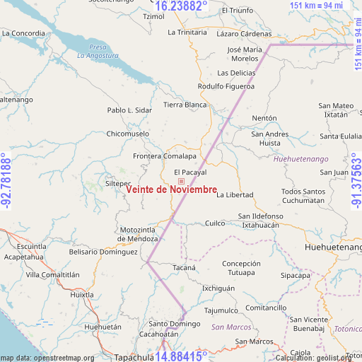
Veinte de Noviembre GPS coordinates[2]
15° 33' 45.36" North, 92° 4' 43.5" West
| Map corner | latitude | longitude |
|---|---|---|
| Upper-left | 16.23882°, | -92.78188° |
| Center: | 15.5626°, | -92.07875° |
| Lower-right: | 14.88415°, | -91.37563° |
| Map W x H: | 150.6×150.6 km | = 93.6×93.6mi |
| max Lat: | 32.7° ⇑98.4% North |
| Veinte de Noviembre: | 15.5626° |
| min Lat: | ⇓1.6% South 14.53588° |
| min Long | Veinte de Novie | max Long |
| -117.105° | -92.07875° | -86.73105° |
| W 94.9%⇐ | ⇒5.1% E |
Elevation
Elevation of Veinte de Noviembre is 1015 m = 3330 ft, and this is 238.7 m = 783 ft below average elevation for this country.
| Max E: |
3497 m = 11473 ft | 59.8% |
| Avg. | 1253.7 m = 4113 ft | |
| Veinte de Noviembre | 1015 m = 3330 ft | |
Min E: |
-1 m = -3 ft | 40.2% |
See also: Mexico elevation on elevation.city.
Geographical zone
Veinte de Noviembre is located in North Torrid zone (between Equator and Tropic of Cancer). Distance of this Northern Tropic circle is 875.5 km =544 mi to North.| Distance of | km | miles | from Veinte de Noviembre |
|---|---|---|---|
| North Pole | 8276.7 | 5142.9 | to North |
| Arctic Circle | 5670.8 | 3523.7 | to North |
| Tropic Cancer | 875.5 | 544 | to North |
| Equator | 1730.4 | 1075.2 | to South |


Nearby cities:
15 places around Veinte de Noviembre: (largest is in red/bold)
• Agua Zarca
10.6 km =6.6 mi,  318°
318°
• El Pacayal
5.6 km =3.5 mi,  44°
44°
• Francisco I. Madero
5.4 km =3.4 mi,  190°
190°
• Guadalupe Victoria
5.2 km =3.2 mi,  19°
19°
• La Montaña
11.8 km =7.3 mi,  275°
275°
• Miguel Hidalgo
5.8 km =3.6 mi,  199°
199°
• Monte Ordóñez
9.9 km =6.2 mi,  269°
269°
• Monte Redondo
10.4 km =6.5 mi, 16°
• Nueva Morelia
9.4 km =5.8 mi,  310°
310°
• Nuevo Amatenango
6.9 km =4.3 mi,  208°
208°
• Ojo de Agua Grande
12 km =7.5 mi,  227°
227°
• Pacayalito
4 km =2.5 mi,  337°
337°
• Potrerillo
9.8 km =6.1 mi, 39°
• Reforma
5.7 km =3.5 mi,  235°
235°
• Río Guerrero
8.7 km =5.4 mi,  285°
285°
Sources, notices
• [Note1] Compared only with cities in Mexico existing in our database
• [Src1] Map data: © OpenStreetMap contributors (CC-BY-SA)
• [Src2] Other city data from geonames.org with taken over terms of usage.
• [Src3] Geographical zone / Annual Mean Temperature by Robert A. Rohde @ Wikipedia
