Monte Redondo geodata
Monte Redondo (Chiapas) is a populated place; located in Mexico in America/Mexico_City (GMT-6) time zone. With population of 1,183 people, there are 7346 cities with bigger population in this country. Compared to other cities in Mexico, 98.3% of cities are located further ↑North; 95.1% of cities are located further ←West and 63.6% of cities have higher elevation than Monte Redondo. Note1


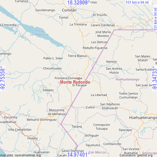
Monte Redondo GPS coordinates[2]
15° 39' 7.812" North, 92° 3' 1.62" West
| Map corner | latitude | longitude |
|---|---|---|
| Upper-left | 16.32809°, | -92.75358° |
| Center: | 15.65217°, | -92.05045° |
| Lower-right: | 14.97401°, | -91.34733° |
| Map W x H: | 150.6×150.6 km | = 93.6×93.6mi |
| max Lat: | 32.7° ⇑98.3% North |
| Monte Redondo: | 15.65217° |
| min Lat: | ⇓1.7% South 14.53588° |
| min Long | Monte Redondo | max Long |
| -117.105° | -92.05045° | -86.73105° |
| W 95.1%⇐ | ⇒4.9% E |
Elevation
Elevation of Monte Redondo is 773 m = 2536 ft, and this is 480.7 m = 1577 ft below average elevation for this country.
| Max E: |
3497 m = 11473 ft | 63.6% |
| Avg. | 1253.7 m = 4113 ft | |
| Monte Redondo | 773 m = 2536 ft | |
Min E: |
-1 m = -3 ft | 36.4% |
See also: Mexico elevation on elevation.city.
Geographical zone
Monte Redondo is located in North Torrid zone (between Equator and Tropic of Cancer). Distance of this Northern Tropic circle is 865.6 km =537.9 mi to North.| Distance of | km | miles | from Monte Redondo |
|---|---|---|---|
| North Pole | 8266.7 | 5136.7 | to North |
| Arctic Circle | 5660.8 | 3517.5 | to North |
| Tropic Cancer | 865.6 | 537.9 | to North |
| Equator | 1740.4 | 1081.4 | to South |


Nearby cities:
15 places around Monte Redondo: (largest is in red/bold)
• Ciudad Cuauhtémoc
5.2 km =3.2 mi,  73°
73°
• Comalapa
9.9 km =6.2 mi,  274°
274°
• El Anonal
9.3 km =5.8 mi,  295°
295°
• El Pacayal
6 km =3.7 mi,  171°
171°
• El Portal
5.6 km =3.5 mi, 299°
• Guadalupe Victoria
5.2 km =3.2 mi,  194°
194°
• La Lima
8.6 km =5.3 mi,  278°
278°
• Nuevo México
6.7 km =4.2 mi,  305°
305°
• Pacayalito
7.7 km =4.8 mi,  216°
216°
• Paso Hondo
4.9 km =3 mi,  44°
44°
• Potrerillo
4 km =2.5 mi,  126°
126°
• Sabinalito
8.8 km =5.5 mi,  51°
51°
• Santa Rita
3.5 km =2.2 mi,  14°
14°
• Santa Rosa
9.8 km =6.1 mi,  324°
324°
• Verapaz
6.7 km =4.2 mi,  349°
349°
Sources, notices
• [Note1] Compared only with cities in Mexico existing in our database
• [Src1] Map data: © OpenStreetMap contributors (CC-BY-SA)
• [Src2] Other city data from geonames.org with taken over terms of usage.
• [Src3] Geographical zone / Annual Mean Temperature by Robert A. Rohde @ Wikipedia
