Pencuyut geodata
Pencuyut (Yucatán) is a populated place; located in Mexico in America/Merida (GMT-6) time zone. With population of 1,524 people, there are 5664 cities with bigger population in this country. Compared to other cities in Mexico, 63.4% of cities are located further ↓South; 98.4% of cities are located further ←West and 87.7% of cities have higher elevation than Pencuyut. Note1


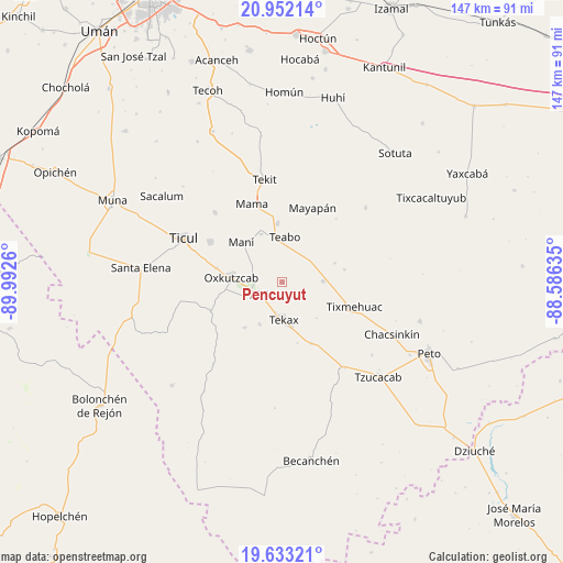
Pencuyut GPS coordinates[2]
20° 17' 38.688" North, 89° 17' 22.092" West
| Map corner | latitude | longitude |
|---|---|---|
| Upper-left | 20.95214°, | -89.9926° |
| Center: | 20.29408°, | -89.28947° |
| Lower-right: | 19.63321°, | -88.58635° |
| Map W x H: | 146.7×146.7 km | = 91.2×91.2mi |
| max Lat: | 32.7° ⇑36.6% North |
| Pencuyut: | 20.29408° |
| min Lat: | ⇓63.4% South 14.53588° |
| min Long | Pencuyut | max Long |
| -117.105° | -89.28947° | -86.73105° |
| W 98.4%⇐ | ⇒1.6% E |
Elevation
Elevation of Pencuyut is 31 m = 102 ft, and this is 1222.7 m = 4011 ft below average elevation for this country.
| Max E: |
3497 m = 11473 ft | 87.7% |
| Avg. | 1253.7 m = 4113 ft | |
| Pencuyut | 31 m = 102 ft | |
Min E: |
-1 m = -3 ft | 12.3% |
See also: Mexico elevation on elevation.city.
Geographical zone
Pencuyut is located in North Torrid zone (between Equator and Tropic of Cancer). Distance of this Northern Tropic circle is 349.4 km =217.1 mi to North.| Distance of | km | miles | from Pencuyut |
|---|---|---|---|
| North Pole | 7750.6 | 4816 | to North |
| Arctic Circle | 5144.7 | 3196.8 | to North |
| Tropic Cancer | 349.4 | 217.1 | to North |
| Equator | 2256.5 | 1402.1 | to South |


Nearby cities:
15 places around Pencuyut: (largest is in red/bold)
• Akil
6.9 km =4.3 mi,  242°
242°
• Chican
14.6 km =9.1 mi,  70°
70°
• Chumayel
15 km =9.3 mi,  355°
355°
• Kancab
12.4 km =7.7 mi,  208°
208°
• Kinil
16.7 km =10.4 mi,  78°
78°
• Mani
14.9 km =9.3 mi,  314°
314°
• Oxkutzkab
13.5 km =8.4 mi,  276°
276°
• Teabo
11.9 km =7.4 mi,  3°
3°
• Tecax
9.9 km =6.2 mi,  177°
177°
• Ticum
17.9 km =11.1 mi,  154°
154°
• Tipical
13.7 km =8.5 mi,  336°
336°
• Tixcuytun
13 km =8.1 mi,  136°
136°
• Xaya
10.7 km =6.6 mi,  88°
88°
• Xohuayan
15.3 km =9.5 mi,  219°
219°
• Yotholin
17.6 km =10.9 mi, 282°
Sources, notices
• [Note1] Compared only with cities in Mexico existing in our database
• [Src1] Map data: © OpenStreetMap contributors (CC-BY-SA)
• [Src2] Other city data from geonames.org with taken over terms of usage.
• [Src3] Geographical zone / Annual Mean Temperature by Robert A. Rohde @ Wikipedia
