Xohuayan geodata
Xohuayan (Yucatán) is a populated place; located in Mexico in America/Merida (GMT-6) time zone. With population of 1,405 people, there are 6164 cities with bigger population in this country. Compared to other cities in Mexico, 61.1% of cities are located further ↓South; 98.3% of cities are located further ←West and 78.8% of cities have higher elevation than Xohuayan. Note1


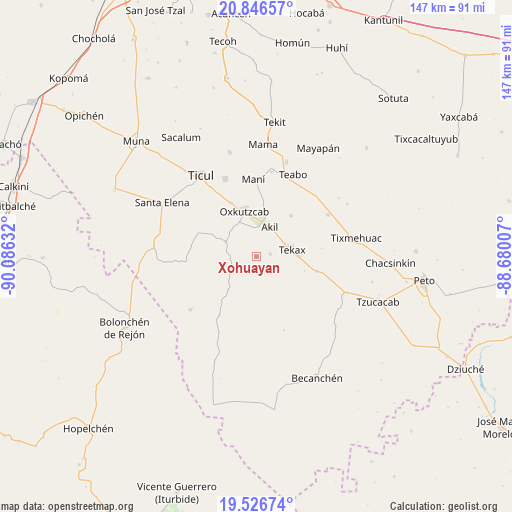
Xohuayan GPS coordinates[2]
20° 11' 16.98" North, 89° 22' 59.484" West
| Map corner | latitude | longitude |
|---|---|---|
| Upper-left | 20.84657°, | -90.08632° |
| Center: | 20.18805°, | -89.38319° |
| Lower-right: | 19.52674°, | -88.68007° |
| Map W x H: | 146.8×146.8 km | = 91.2×91.2mi |
| max Lat: | 32.7° ⇑38.9% North |
| Xohuayan: | 20.18805° |
| min Lat: | ⇓61.1% South 14.53588° |
| min Long | Xohuayan | max Long |
| -117.105° | -89.38319° | -86.73105° |
| W 98.3%⇐ | ⇒1.7% E |
Elevation
Elevation of Xohuayan is 115 m = 377 ft, and this is 1138.7 m = 3736 ft below average elevation for this country.
| Max E: |
3497 m = 11473 ft | 78.8% |
| Avg. | 1253.7 m = 4113 ft | |
| Xohuayan | 115 m = 377 ft | |
Min E: |
-1 m = -3 ft | 21.2% |
See also: Mexico elevation on elevation.city.
Geographical zone
Xohuayan is located in North Torrid zone (between Equator and Tropic of Cancer). Distance of this Northern Tropic circle is 361.2 km =224.4 mi to North.| Distance of | km | miles | from Xohuayan |
|---|---|---|---|
| North Pole | 7762.4 | 4823.3 | to North |
| Arctic Circle | 5156.5 | 3204.1 | to North |
| Tropic Cancer | 361.2 | 224.4 | to North |
| Equator | 2244.7 | 1394.8 | to South |


Nearby cities:
15 places around Xohuayan: (largest is in red/bold)
• Akil
9.4 km =5.8 mi,  23°
23°
• Dzan
24 km =14.9 mi,  338°
338°
• Emiliano Zapata
9.8 km =6.1 mi,  295°
295°
• Kancab
4 km =2.5 mi,  77°
77°
• Mani
22.2 km =13.8 mi,  357°
357°
• Oxkutzkab
13.8 km =8.6 mi, 344°
• Pencuyut
15.3 km =9.5 mi,  39°
39°
• Pustunich
24.2 km =15 mi,  326°
326°
• Tecax
10.4 km =6.5 mi, 79°
• Ticum
17.9 km =11.1 mi,  104°
104°
• Tixcuytun
18.8 km =11.7 mi, 82°
• Xaya
23.8 km =14.8 mi,  59°
59°
• Xul
12.7 km =7.9 mi,  220°
220°
• Yaxhachen
24.4 km =15.2 mi,  231°
231°
• Yotholin
17.2 km =10.7 mi, 334°
Sources, notices
• [Note1] Compared only with cities in Mexico existing in our database
• [Src1] Map data: © OpenStreetMap contributors (CC-BY-SA)
• [Src2] Other city data from geonames.org with taken over terms of usage.
• [Src3] Geographical zone / Annual Mean Temperature by Robert A. Rohde @ Wikipedia
