Chican geodata
Chican (Yucatán) is a populated place; located in Mexico in America/Merida (GMT-6) time zone. With population of 624 people, there are 13853 cities with bigger population in this country. Compared to other cities in Mexico, 64.3% of cities are located further ↓South; 98.6% of cities are located further ←West and 88.3% of cities have higher elevation than Chican. Note1


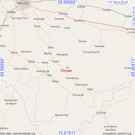
Chican GPS coordinates[2]
20° 20' 19.644" North, 89° 9' 28.26" West
| Map corner | latitude | longitude |
|---|---|---|
| Upper-left | 20.99666°, | -89.86098° |
| Center: | 20.33879°, | -89.15785° |
| Lower-right: | 19.67811°, | -88.45473° |
| Map W x H: | 146.6×146.6 km | = 91.1×91.1mi |
| max Lat: | 32.7° ⇑35.7% North |
| Chican: | 20.33879° |
| min Lat: | ⇓64.3% South 14.53588° |
| min Long | Chican | max Long |
| -117.105° | -89.15785° | -86.73105° |
| W 98.6%⇐ | ⇒1.4% E |
Elevation
Elevation of Chican is 29 m = 95 ft, and this is 1224.7 m = 4018 ft below average elevation for this country.
| Max E: |
3497 m = 11473 ft | 88.3% |
| Avg. | 1253.7 m = 4113 ft | |
| Chican | 29 m = 95 ft | |
Min E: |
-1 m = -3 ft | 11.7% |
See also: Mexico elevation on elevation.city.
Geographical zone
Chican is located in North Torrid zone (between Equator and Tropic of Cancer). Distance of this Northern Tropic circle is 344.5 km =214.1 mi to North.| Distance of | km | miles | from Chican |
|---|---|---|---|
| North Pole | 7745.6 | 4812.9 | to North |
| Arctic Circle | 5139.7 | 3193.7 | to North |
| Tropic Cancer | 344.5 | 214.1 | to North |
| Equator | 2261.5 | 1405.2 | to South |


Nearby cities:
15 places around Chican: (largest is in red/bold)
• Akil
21.4 km =13.3 mi,  247°
247°
• Cantamayec
16.6 km =10.3 mi,  28°
28°
• Chumayel
17.9 km =11.1 mi,  303°
303°
• Kimbila
8.9 km =5.5 mi,  121°
121°
• Kinil
3.1 km =1.9 mi, 122°
• Mayapan
15.6 km =9.7 mi,  337°
337°
• Pencuyut
14.6 km =9.1 mi, 250°
• Sabacché
13.8 km =8.6 mi,  100°
100°
• Teabo
14.8 km =9.2 mi, 297°
• Tecax
19.9 km =12.4 mi,  221°
221°
• Ticum
22 km =13.7 mi,  196°
196°
• Tipical
20.7 km =12.9 mi,  291°
291°
• Tixcuytun
15.2 km =9.4 mi, 198°
• Tixmehuac
12.5 km =7.8 mi,  155°
155°
• Xaya
5.6 km =3.5 mi,  212°
212°
Sources, notices
• [Note1] Compared only with cities in Mexico existing in our database
• [Src1] Map data: © OpenStreetMap contributors (CC-BY-SA)
• [Src2] Other city data from geonames.org with taken over terms of usage.
• [Src3] Geographical zone / Annual Mean Temperature by Robert A. Rohde @ Wikipedia
