Tipical geodata
Tipical (Yucatán) is a populated place; located in Mexico in America/Merida (GMT-6) time zone. With population of 951 people, there are 9161 cities with bigger population in this country. Compared to other cities in Mexico, 65.8% of cities are located further ↓South; 98.3% of cities are located further ←West and 90.4% of cities have higher elevation than Tipical. Note1


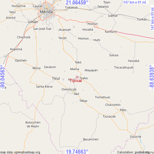
Tipical GPS coordinates[2]
20° 24' 25.272" North, 89° 20' 33" West
| Map corner | latitude | longitude |
|---|---|---|
| Upper-left | 21.06459°, | -90.04563° |
| Center: | 20.40702°, | -89.3425° |
| Lower-right: | 19.74663°, | -88.63938° |
| Map W x H: | 146.5×146.5 km | = 91×91mi |
| max Lat: | 32.7° ⇑34.2% North |
| Tipical: | 20.40702° |
| min Lat: | ⇓65.8% South 14.53588° |
| min Long | Tipical | max Long |
| -117.105° | -89.3425° | -86.73105° |
| W 98.3%⇐ | ⇒1.7% E |
Elevation
Elevation of Tipical is 23 m = 75 ft, and this is 1230.7 m = 4038 ft below average elevation for this country.
| Max E: |
3497 m = 11473 ft | 90.4% |
| Avg. | 1253.7 m = 4113 ft | |
| Tipical | 23 m = 75 ft | |
Min E: |
-1 m = -3 ft | 9.6% |
See also: Mexico elevation on elevation.city.
Geographical zone
Tipical is located in North Torrid zone (between Equator and Tropic of Cancer). Distance of this Northern Tropic circle is 336.9 km =209.3 mi to North.| Distance of | km | miles | from Tipical |
|---|---|---|---|
| North Pole | 7738 | 4808.2 | to North |
| Arctic Circle | 5132.1 | 3188.9 | to North |
| Tropic Cancer | 336.9 | 209.3 | to North |
| Equator | 2269 | 1409.9 | to South |


Nearby cities:
15 places around Tipical: (largest is in red/bold)
• Akil
15.7 km =9.8 mi,  182°
182°
• Chapab
13.3 km =8.3 mi,  295°
295°
• Chumayel
4.9 km =3 mi,  61°
61°
• Dzan
13.3 km =8.3 mi,  261°
261°
• Mama
8.3 km =5.2 mi,  343°
343°
• Mani
5.6 km =3.5 mi,  247°
247°
• Mayapan
15 km =9.3 mi, 63°
• Oxkutzkab
13.6 km =8.5 mi,  215°
215°
• Pencuyut
13.7 km =8.5 mi,  156°
156°
• Pustunich
18.1 km =11.2 mi, 256°
• Teabo
6.2 km =3.9 mi,  96°
96°
• Tekit
14.2 km =8.8 mi,  3°
3°
• Ticul
20.1 km =12.5 mi,  267°
267°
• Xaya
20.4 km =12.7 mi,  127°
127°
• Yotholin
14.6 km =9.1 mi,  232°
232°
Sources, notices
• [Note1] Compared only with cities in Mexico existing in our database
• [Src1] Map data: © OpenStreetMap contributors (CC-BY-SA)
• [Src2] Other city data from geonames.org with taken over terms of usage.
• [Src3] Geographical zone / Annual Mean Temperature by Robert A. Rohde @ Wikipedia
