Paso de Ovejas geodata
Paso de Ovejas (Veracruz) is a seat of a second-order administrative division; located in Mexico in America/Mexico_City (GMT-6) time zone. With population of 7,468 people, there are 1248 cities with bigger population in this country. Compared to other cities in Mexico, 59.1% of cities are located further ↑North; 80% of cities are located further ←West and 83.4% of cities have higher elevation than Paso de Ovejas. Note1


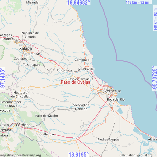
Paso de Ovejas GPS coordinates[2]
19° 17' 4.2" North, 96° 26' 25.332" West
| Map corner | latitude | longitude |
|---|---|---|
| Upper-left | 19.94682°, | -97.1435° |
| Center: | 19.2845°, | -96.44037° |
| Lower-right: | 18.6195°, | -95.73725° |
| Map W x H: | 147.6×147.6 km | = 91.7×91.7mi |
| max Lat: | 32.7° ⇑59.1% North |
| Paso de Ovejas: | 19.2845° |
| min Lat: | ⇓40.9% South 14.53588° |
| min Long | Paso de Ovejas | max Long |
| -117.105° | -96.44037° | -86.73105° |
| W 80%⇐ | ⇒20% E |
Elevation
Elevation of Paso de Ovejas is 57 m = 187 ft, and this is 1196.7 m = 3926 ft below average elevation for this country.
| Max E: |
3497 m = 11473 ft | 83.4% |
| Avg. | 1253.7 m = 4113 ft | |
| Paso de Ovejas | 57 m = 187 ft | |
Min E: |
-1 m = -3 ft | 16.6% |
See also: Mexico elevation on elevation.city.
Geographical zone
Paso de Ovejas is located in North Torrid zone (between Equator and Tropic of Cancer). Distance of this Northern Tropic circle is 461.7 km =286.9 mi to North.| Distance of | km | miles | from Paso de Ovejas |
|---|---|---|---|
| North Pole | 7862.8 | 4885.7 | to North |
| Arctic Circle | 5256.9 | 3266.5 | to North |
| Tropic Cancer | 461.7 | 286.9 | to North |
| Equator | 2144.2 | 1332.3 | to South |


Nearby cities:
15 places around Paso de Ovejas: (largest is in red/bold)
• Bandera de Juárez
9.7 km =6 mi,  169°
169°
• Cerro Guzmán
8.5 km =5.3 mi,  130°
130°
• Chichicaxtle
7.2 km =4.5 mi,  335°
335°
• El Crucero
9.3 km =5.8 mi,  292°
292°
• El Hatito
5 km =3.1 mi,  99°
99°
• El Mango
7.1 km =4.4 mi,  52°
52°
• El Pochote
8.2 km =5.1 mi,  150°
150°
• La Ceiba
6.9 km =4.3 mi,  60°
60°
• Loma Fina (Loma Pelona)
3.9 km =2.4 mi, 126°
• Palmaritos
7.8 km =4.8 mi,  156°
156°
• Plan del Manantial
10.1 km =6.3 mi,  135°
135°
• Tamarindo
8.2 km =5.1 mi,  319°
319°
• Tierra Colorada
9.9 km =6.2 mi, 131°
• Tolome
5.2 km =3.2 mi,  112°
112°
• Yucatán
10.6 km =6.6 mi, 50°
Sources, notices
• [Note1] Compared only with cities in Mexico existing in our database
• [Src1] Map data: © OpenStreetMap contributors (CC-BY-SA)
• [Src2] Other city data from geonames.org with taken over terms of usage.
• [Src3] Geographical zone / Annual Mean Temperature by Robert A. Rohde @ Wikipedia
