Palmaritos geodata
Palmaritos (Veracruz) is a populated place; located in Mexico in America/Mexico_City (GMT-6) time zone. With population of 898 people, there are 9712 cities with bigger population in this country. Compared to other cities in Mexico, 60.7% of cities are located further ↑North; 80.2% of cities are located further ←West and 83.8% of cities have higher elevation than Palmaritos. Note1


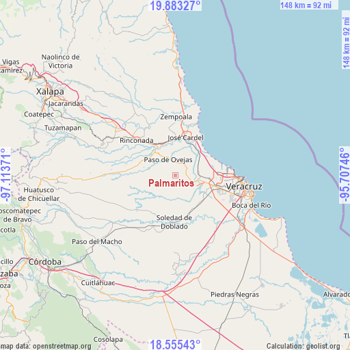
Palmaritos GPS coordinates[2]
19° 13' 14.484" North, 96° 24' 38.088" West
| Map corner | latitude | longitude |
|---|---|---|
| Upper-left | 19.88327°, | -97.11371° |
| Center: | 19.22069°, | -96.41058° |
| Lower-right: | 18.55543°, | -95.70746° |
| Map W x H: | 147.6×147.6 km | = 91.7×91.7mi |
| max Lat: | 32.7° ⇑60.7% North |
| Palmaritos: | 19.22069° |
| min Lat: | ⇓39.3% South 14.53588° |
| min Long | Palmaritos | max Long |
| -117.105° | -96.41058° | -86.73105° |
| W 80.2%⇐ | ⇒19.8% E |
Elevation
Elevation of Palmaritos is 53 m = 174 ft, and this is 1200.7 m = 3939 ft below average elevation for this country.
| Max E: |
3497 m = 11473 ft | 83.8% |
| Avg. | 1253.7 m = 4113 ft | |
| Palmaritos | 53 m = 174 ft | |
Min E: |
-1 m = -3 ft | 16.2% |
See also: Mexico elevation on elevation.city.
Geographical zone
Palmaritos is located in North Torrid zone (between Equator and Tropic of Cancer). Distance of this Northern Tropic circle is 468.8 km =291.3 mi to North.| Distance of | km | miles | from Palmaritos |
|---|---|---|---|
| North Pole | 7869.9 | 4890.1 | to North |
| Arctic Circle | 5264 | 3270.9 | to North |
| Tropic Cancer | 468.8 | 291.3 | to North |
| Equator | 2137.1 | 1327.9 | to South |


Nearby cities:
15 places around Palmaritos: (largest is in red/bold)
• Bandera de Juárez
2.8 km =1.7 mi,  207°
207°
• Cerro Guzmán
3.7 km =2.3 mi,  64°
64°
• El Hatito
6.6 km =4.1 mi,  15°
15°
• El Pochote
0.9 km =0.6 mi,  94°
94°
• Loma Fina (Loma Pelona)
4.7 km =2.9 mi,  0°
0°
• Loma del Nanche
3.5 km =2.2 mi,  128°
128°
• Mata Cazuela
9.1 km =5.7 mi, 207°
• Paso Real
6.6 km =4.1 mi, 129°
• Paso San Juan
9.3 km =5.8 mi,  102°
102°
• Paso de Ovejas
7.8 km =4.8 mi,  336°
336°
• Plan del Manantial
3.9 km =2.4 mi, 91°
• Puente Jula
6.9 km =4.3 mi,  109°
109°
• Tenenexpan
9 km =5.6 mi,  169°
169°
• Tierra Colorada
4.4 km =2.7 mi,  83°
83°
• Tolome
5.4 km =3.4 mi, 18°
Sources, notices
• [Note1] Compared only with cities in Mexico existing in our database
• [Src1] Map data: © OpenStreetMap contributors (CC-BY-SA)
• [Src2] Other city data from geonames.org with taken over terms of usage.
• [Src3] Geographical zone / Annual Mean Temperature by Robert A. Rohde @ Wikipedia
