Chichicaxtle geodata
Chichicaxtle (Veracruz) is a populated place; located in Mexico in America/Mexico_City (GMT-6) time zone. With population of 1,910 people, there are 4552 cities with bigger population in this country. Compared to other cities in Mexico, 57.8% of cities are located further ↑North; 79.9% of cities are located further ←West and 78.3% of cities have higher elevation than Chichicaxtle. Note1


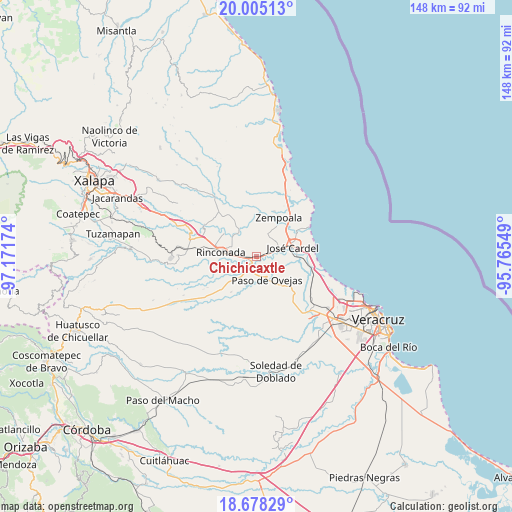
Chichicaxtle GPS coordinates[2]
19° 20' 35.016" North, 96° 28' 6.996" West
| Map corner | latitude | longitude |
|---|---|---|
| Upper-left | 20.00513°, | -97.17174° |
| Center: | 19.34306°, | -96.46861° |
| Lower-right: | 18.67829°, | -95.76549° |
| Map W x H: | 147.5×147.5 km | = 91.7×91.7mi |
| max Lat: | 32.7° ⇑57.8% North |
| Chichicaxtle: | 19.34306° |
| min Lat: | ⇓42.2% South 14.53588° |
| min Long | Chichicaxtle | max Long |
| -117.105° | -96.46861° | -86.73105° |
| W 79.9%⇐ | ⇒20.1% E |
Elevation
Elevation of Chichicaxtle is 125 m = 410 ft, and this is 1128.7 m = 3703 ft below average elevation for this country.
| Max E: |
3497 m = 11473 ft | 78.3% |
| Avg. | 1253.7 m = 4113 ft | |
| Chichicaxtle | 125 m = 410 ft | |
Min E: |
-1 m = -3 ft | 21.7% |
See also: Mexico elevation on elevation.city.
Geographical zone
Chichicaxtle is located in North Torrid zone (between Equator and Tropic of Cancer). Distance of this Northern Tropic circle is 455.2 km =282.8 mi to North.| Distance of | km | miles | from Chichicaxtle |
|---|---|---|---|
| North Pole | 7856.3 | 4881.7 | to North |
| Arctic Circle | 5250.4 | 3262.4 | to North |
| Tropic Cancer | 455.2 | 282.8 | to North |
| Equator | 2150.7 | 1336.4 | to South |


Nearby cities:
15 places around Chichicaxtle: (largest is in red/bold)
• Cabezas
9.5 km =5.9 mi,  70°
70°
• El Crucero
6.4 km =4 mi,  242°
242°
• El Hatito
10.7 km =6.6 mi,  132°
132°
• El Mango
8.9 km =5.5 mi,  104°
104°
• El Palmar
6.5 km =4 mi,  38°
38°
• Infonavit el Pando I
10.9 km =6.8 mi,  54°
54°
• José Cardel
10.8 km =6.7 mi,  75°
75°
• José Guadalupe Rodríguez (Despoblado)
10.4 km =6.5 mi,  32°
32°
• La Ceiba
9.5 km =5.9 mi,  108°
108°
• Loma Fina (Loma Pelona)
10.8 km =6.7 mi,  145°
145°
• Los Ídolos
9.2 km =5.7 mi,  325°
325°
• Paso de Ovejas
7.2 km =4.5 mi,  155°
155°
• Real del Oro
10.9 km =6.8 mi, 34°
• Rinconada
10.3 km =6.4 mi,  277°
277°
• Tamarindo
2.4 km =1.5 mi,  262°
262°
Sources, notices
• [Note1] Compared only with cities in Mexico existing in our database
• [Src1] Map data: © OpenStreetMap contributors (CC-BY-SA)
• [Src2] Other city data from geonames.org with taken over terms of usage.
• [Src3] Geographical zone / Annual Mean Temperature by Robert A. Rohde @ Wikipedia
