Palmillas geodata
Palmillas (State of Mexico) is a populated place; located in Mexico in America/Mexico_City (GMT-6) time zone. With population of 1,717 people, there are 5057 cities with bigger population in this country. Compared to other cities in Mexico, 57.7% of cities are located further ↑North; 60% of cities are located further →East and 96.2% of cities have lower elevation than Palmillas. Note1


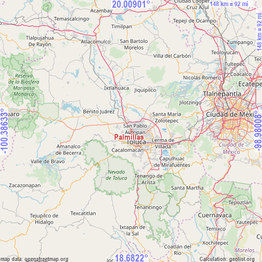
Palmillas GPS coordinates[2]
19° 20' 49.02" North, 99° 40' 59.52" West
| Map corner | latitude | longitude |
|---|---|---|
| Upper-left | 20.00901°, | -100.38633° |
| Center: | 19.34695°, | -99.6832° |
| Lower-right: | 18.6822°, | -98.98008° |
| Map W x H: | 147.5×147.5 km | = 91.7×91.7mi |
| max Lat: | 32.7° ⇑57.7% North |
| Palmillas: | 19.34695° |
| min Lat: | ⇓42.3% South 14.53588° |
| min Long | Palmillas | max Long |
| -117.105° | -99.6832° | -86.73105° |
| W 40%⇐ | ⇒60% E |
Elevation
Elevation of Palmillas is 2634 m = 8642 ft, and this is 1380.3 m = 4529 ft above average elevation for this country.
| Max E: |
3497 m = 11473 ft | 3.8% |
| Palmillas | 2634 m 8642 ft | |
| Avg. | 1253.7 m = 4113 ft | |
Min E: |
-1 m = -3 ft | 96.2% |
See also: Mexico elevation on elevation.city.
Geographical zone
Palmillas is located in North Torrid zone (between Equator and Tropic of Cancer). Distance of this Northern Tropic circle is 454.7 km =282.5 mi to North.| Distance of | km | miles | from Palmillas |
|---|---|---|---|
| North Pole | 7855.9 | 4881.4 | to North |
| Arctic Circle | 5250 | 3262.2 | to North |
| Tropic Cancer | 454.7 | 282.5 | to North |
| Equator | 2151.2 | 1336.7 | to South |


Nearby cities:
15 places around Palmillas: (largest is in red/bold)
• Barrio Bordo Nuevo
3.7 km =2.3 mi,  16°
16°
• Barrio Santa Cruz
2.2 km =1.4 mi,  77°
77°
• Barrio de Jesús Fracción Primera
2.3 km =1.4 mi,  350°
350°
• Calixtlahuaca
1.3 km =0.8 mi,  208°
208°
• Colonia Aviación Autopan
3.7 km =2.3 mi,  344°
344°
• Ejido San Marcos Yachihuacaltepec
5 km =3.1 mi,  313°
313°
• La Loma Cuexcontitlán
5.1 km =3.2 mi,  44°
44°
• La Planada (El Arenal)
1.7 km =1.1 mi,  156°
156°
• Ojo de Agua Autopan
1.8 km =1.1 mi,  330°
330°
• San Carlos Autopan
4.3 km =2.7 mi, 354°
• San Marcos Yachihuacaltepec
2.7 km =1.7 mi,  170°
170°
• San Martín Toltepec
2.4 km =1.5 mi,  283°
283°
• San Pablo Autopan
2.9 km =1.8 mi,  68°
68°
• Santiaguito Tlalcilalcalli
4.7 km =2.9 mi,  260°
260°
• Tecaxic
4.3 km =2.7 mi,  231°
231°
Sources, notices
• [Note1] Compared only with cities in Mexico existing in our database
• [Src1] Map data: © OpenStreetMap contributors (CC-BY-SA)
• [Src2] Other city data from geonames.org with taken over terms of usage.
• [Src3] Geographical zone / Annual Mean Temperature by Robert A. Rohde @ Wikipedia
