San Pablo Autopan geodata
San Pablo Autopan (Morelos) is a populated place; located in Mexico in America/Mexico_City (GMT-6) time zone. With population of 35,141 people, there are 292 cities with bigger population in this country. Compared to other cities in Mexico, 57.4% of cities are located further ↑North; 59.6% of cities are located further →East and 95.7% of cities have lower elevation than San Pablo Autopan. Note1


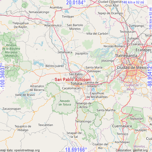
San Pablo Autopan GPS coordinates[2]
19° 21' 22.968" North, 99° 39' 26.064" West
| Map corner | latitude | longitude |
|---|---|---|
| Upper-left | 20.0184°, | -100.36037° |
| Center: | 19.35638°, | -99.65724° |
| Lower-right: | 18.69166°, | -98.95412° |
| Map W x H: | 147.5×147.5 km | = 91.7×91.7mi |
| max Lat: | 32.7° ⇑57.4% North |
| San Pablo Autopan: | 19.35638° |
| min Lat: | ⇓42.6% South 14.53588° |
| min Long | San Pablo Autop | max Long |
| -117.105° | -99.65724° | -86.73105° |
| W 40.4%⇐ | ⇒59.6% E |
Elevation
Elevation of San Pablo Autopan is 2613 m = 8573 ft, and this is 1359.3 m = 4460 ft above average elevation for this country.
| Max E: |
3497 m = 11473 ft | 4.3% |
| San Pablo Autopan | 2613 m 8573 ft | |
| Avg. | 1253.7 m = 4113 ft | |
Min E: |
-1 m = -3 ft | 95.7% |
See also: Mexico elevation on elevation.city.
Geographical zone
San Pablo Autopan is located in North Torrid zone (between Equator and Tropic of Cancer). Distance of this Northern Tropic circle is 453.7 km =281.9 mi to North.| Distance of | km | miles | from San Pablo Autopan |
|---|---|---|---|
| North Pole | 7854.8 | 4880.7 | to North |
| Arctic Circle | 5248.9 | 3261.5 | to North |
| Tropic Cancer | 453.7 | 281.9 | to North |
| Equator | 2152.2 | 1337.3 | to South |


Nearby cities:
15 places around San Pablo Autopan: (largest is in red/bold)
• Barrio Bordo Nuevo
3 km =1.9 mi,  326°
326°
• Barrio Santa Cruz
0.8 km =0.5 mi,  226°
226°
• Barrio de Jesús Fracción Primera
3.4 km =2.1 mi,  292°
292°
• Barrio del Cajón
3.9 km =2.4 mi,  358°
358°
• Calixtlahuaca
4 km =2.5 mi,  236°
236°
• Fraccionamiento Real de San Pablo
3.8 km =2.4 mi,  13°
13°
• Jicaltepec Autopan
2.4 km =1.5 mi,  45°
45°
• Jicaltepec Cuexcontitlán
3.6 km =2.2 mi,  59°
59°
• La Loma Cuexcontitlán
2.8 km =1.7 mi,  18°
18°
• La Planada (El Arenal)
3.3 km =2.1 mi,  218°
218°
• Ojo de Agua Autopan
3.6 km =2.2 mi,  278°
278°
• Palmillas
2.9 km =1.8 mi,  248°
248°
• San Andrés Cuexcontitlán
3.8 km =2.4 mi,  85°
85°
• San Diego Linares
3.9 km =2.4 mi,  31°
31°
• San Marcos Yachihuacaltepec
4.3 km =2.7 mi,  211°
211°
Sources, notices
• [Note1] Compared only with cities in Mexico existing in our database
• [Src1] Map data: © OpenStreetMap contributors (CC-BY-SA)
• [Src2] Other city data from geonames.org with taken over terms of usage.
• [Src3] Geographical zone / Annual Mean Temperature by Robert A. Rohde @ Wikipedia
