Oxiacaque geodata
Oxiacaque (Tabasco) is a populated place; located in Mexico in America/Mexico_City (GMT-6) time zone. With population of 1,928 people, there are 4510 cities with bigger population in this country. Compared to other cities in Mexico, 76% of cities are located further ↑North; 88.9% of cities are located further ←West and 99.3% of cities have higher elevation than Oxiacaque. Note1


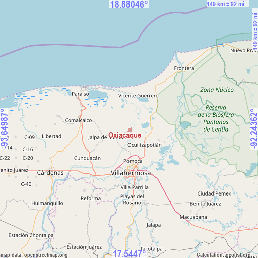
Oxiacaque GPS coordinates[2]
18° 12' 49.896" North, 92° 56' 48.264" West
| Map corner | latitude | longitude |
|---|---|---|
| Upper-left | 18.88046°, | -93.64987° |
| Center: | 18.21386°, | -92.94674° |
| Lower-right: | 17.5447°, | -92.24362° |
| Map W x H: | 148.5×148.5 km | = 92.3×92.3mi |
| max Lat: | 32.7° ⇑76% North |
| Oxiacaque: | 18.21386° |
| min Lat: | ⇓24% South 14.53588° |
| min Long | Oxiacaque | max Long |
| -117.105° | -92.94674° | -86.73105° |
| W 88.9%⇐ | ⇒11.1% E |
Elevation
Elevation of Oxiacaque is 5 m = 16 ft, and this is 1248.7 m = 4097 ft below average elevation for this country.
| Max E: |
3497 m = 11473 ft | 99.3% |
| Avg. | 1253.7 m = 4113 ft | |
| Oxiacaque | 5 m = 16 ft | |
Min E: |
-1 m = -3 ft | 0.7% |
See also: Mexico elevation on elevation.city.
Geographical zone
Oxiacaque is located in North Torrid zone (between Equator and Tropic of Cancer). Distance of this Northern Tropic circle is 580.7 km =360.8 mi to North.| Distance of | km | miles | from Oxiacaque |
|---|---|---|---|
| North Pole | 7981.9 | 4959.7 | to North |
| Arctic Circle | 5376 | 3340.5 | to North |
| Tropic Cancer | 580.7 | 360.8 | to North |
| Equator | 2025.2 | 1258.4 | to South |


Nearby cities:
15 places around Oxiacaque: (largest is in red/bold)
• Banderas (Guatacalca 2da. Sección)
8.6 km =5.3 mi,  143°
143°
• Chicozapote
3.1 km =1.9 mi,  93°
93°
• Corriente 1ra. Sección
8 km =5 mi,  218°
218°
• El Zapote
7.2 km =4.5 mi,  187°
187°
• Guatacalca
6.3 km =3.9 mi,  212°
212°
• Guaytalpa
9 km =5.6 mi,  272°
272°
• Isla Guadalupe
0.4 km =0.2 mi,  58°
58°
• Jiménez
6.1 km =3.8 mi,  166°
166°
• Mazateupa
6.7 km =4.2 mi,  258°
258°
• Nacajuca
9 km =5.6 mi,  237°
237°
• Olcuatitán
3 km =1.9 mi, 210°
• San Simón
9.6 km =6 mi,  285°
285°
• Tapotzingo
7.2 km =4.5 mi, 261°
• Tecoluta 2da. Sección
8.4 km =5.2 mi, 293°
• Tucta
5.6 km =3.5 mi,  246°
246°
Sources, notices
• [Note1] Compared only with cities in Mexico existing in our database
• [Src1] Map data: © OpenStreetMap contributors (CC-BY-SA)
• [Src2] Other city data from geonames.org with taken over terms of usage.
• [Src3] Geographical zone / Annual Mean Temperature by Robert A. Rohde @ Wikipedia
