Nacajuca geodata
Nacajuca (Tabasco) is a seat of a second-order administrative division; located in Mexico in America/Mexico_City (GMT-6) time zone. With population of 11,289 people, there are 845 cities with bigger population in this country. Compared to other cities in Mexico, 76.6% of cities are located further ↑North; 88.4% of cities are located further ←West and 98.7% of cities have higher elevation than Nacajuca. Note1


Nacajuca GPS coordinates[2]
18° 10' 10.956" North, 93° 1' 6.348" West
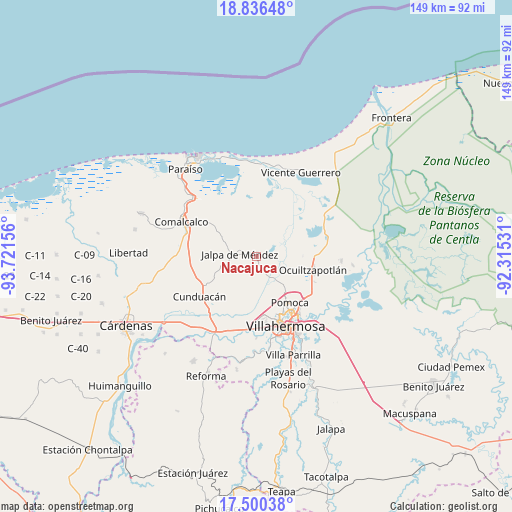
| Map corner | latitude | longitude |
|---|---|---|
| Upper-left | 18.83648°, | -93.72156° |
| Center: | 18.16971°, | -93.01843° |
| Lower-right: | 17.50038°, | -92.31531° |
| Map W x H: | 148.6×148.6 km | = 92.3×92.3mi |
| max Lat: | 32.7° ⇑76.6% North |
| Nacajuca: | 18.16971° |
| min Lat: | ⇓23.4% South 14.53588° |
| min Long | Nacajuca | max Long |
| -117.105° | -93.01843° | -86.73105° |
| W 88.4%⇐ | ⇒11.6% E |
Elevation
Elevation of Nacajuca is 7 m = 23 ft, and this is 1246.7 m = 4090 ft below average elevation for this country.
| Max E: |
3497 m = 11473 ft | 98.7% |
| Avg. | 1253.7 m = 4113 ft | |
| Nacajuca | 7 m = 23 ft | |
Min E: |
-1 m = -3 ft | 1.3% |
See also: Mexico elevation on elevation.city.
Geographical zone
Nacajuca is located in North Torrid zone (between Equator and Tropic of Cancer). Distance of this Northern Tropic circle is 585.6 km =363.9 mi to North.| Distance of | km | miles | from Nacajuca |
|---|---|---|---|
| North Pole | 7986.8 | 4962.8 | to North |
| Arctic Circle | 5380.9 | 3343.5 | to North |
| Tropic Cancer | 585.6 | 363.9 | to North |
| Equator | 2020.3 | 1255.4 | to South |


Nearby cities:
15 places around Nacajuca: (largest is in red/bold)
• Corriente 1ra. Sección
2.9 km =1.8 mi,  117°
117°
• El Zapote
7 km =4.3 mi,  108°
108°
• Guatacalca
4.2 km =2.6 mi,  95°
95°
• Guaytalpa
5.5 km =3.4 mi,  344°
344°
• Jalpa de Méndez
4.8 km =3 mi,  278°
278°
• Jalupa
4.6 km =2.9 mi,  217°
217°
• La Cruz
4.1 km =2.5 mi,  197°
197°
• Mazateupa
3.7 km =2.3 mi,  14°
14°
• Nicolás Bravo
7 km =4.3 mi,  256°
256°
• Olcuatitán
6.5 km =4 mi,  69°
69°
• Soyataco
7.4 km =4.6 mi,  307°
307°
• Tapotzingo
3.9 km =2.4 mi, 6°
• Taxco
3.7 km =2.3 mi,  157°
157°
• Tierras Peleadas (Tierras Amigas)
3.3 km =2.1 mi, 216°
• Tucta
3.6 km =2.2 mi,  42°
42°
Sources, notices
• [Note1] Compared only with cities in Mexico existing in our database
• [Src1] Map data: © OpenStreetMap contributors (CC-BY-SA)
• [Src2] Other city data from geonames.org with taken over terms of usage.
• [Src3] Geographical zone / Annual Mean Temperature by Robert A. Rohde @ Wikipedia
