Tapotzingo geodata
Tapotzingo (Tabasco) is a populated place; located in Mexico in America/Mexico_City (GMT-6) time zone. With population of 2,890 people, there are 3077 cities with bigger population in this country. Compared to other cities in Mexico, 76.2% of cities are located further ↑North; 88.5% of cities are located further ←West and 99.1% of cities have higher elevation than Tapotzingo. Note1


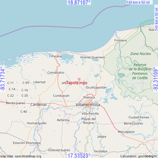
Tapotzingo GPS coordinates[2]
18° 12' 15.948" North, 93° 0' 51.156" West
| Map corner | latitude | longitude |
|---|---|---|
| Upper-left | 18.87107°, | -93.71734° |
| Center: | 18.20443°, | -93.01421° |
| Lower-right: | 17.53523°, | -92.31109° |
| Map W x H: | 148.5×148.5 km | = 92.3×92.3mi |
| max Lat: | 32.7° ⇑76.2% North |
| Tapotzingo: | 18.20443° |
| min Lat: | ⇓23.8% South 14.53588° |
| min Long | Tapotzingo | max Long |
| -117.105° | -93.01421° | -86.73105° |
| W 88.5%⇐ | ⇒11.5% E |
Elevation
Elevation of Tapotzingo is 6 m = 20 ft, and this is 1247.7 m = 4094 ft below average elevation for this country.
| Max E: |
3497 m = 11473 ft | 99.1% |
| Avg. | 1253.7 m = 4113 ft | |
| Tapotzingo | 6 m = 20 ft | |
Min E: |
-1 m = -3 ft | 0.9% |
See also: Mexico elevation on elevation.city.
Geographical zone
Tapotzingo is located in North Torrid zone (between Equator and Tropic of Cancer). Distance of this Northern Tropic circle is 581.8 km =361.5 mi to North.| Distance of | km | miles | from Tapotzingo |
|---|---|---|---|
| North Pole | 7982.9 | 4960.3 | to North |
| Arctic Circle | 5377 | 3341.1 | to North |
| Tropic Cancer | 581.8 | 361.5 | to North |
| Equator | 2024.1 | 1257.7 | to South |


Nearby cities:
15 places around Tapotzingo: (largest is in red/bold)
• Corriente 1ra. Sección
5.6 km =3.5 mi,  157°
157°
• Guatacalca
5.7 km =3.5 mi,  138°
138°
• Guaytalpa
2.4 km =1.5 mi,  306°
306°
• Jalpa de Méndez
6 km =3.7 mi,  238°
238°
• La Trinidad
7.2 km =4.5 mi,  300°
300°
• Mazateupa
0.6 km =0.4 mi,  115°
115°
• Nacajuca
3.9 km =2.4 mi,  186°
186°
• Olcuatitán
5.8 km =3.6 mi,  105°
105°
• Oxiacaque
7.2 km =4.5 mi,  81°
81°
• San Simón
4.2 km =2.6 mi,  329°
329°
• Soyataco
6.4 km =4 mi,  275°
275°
• Taxco
7.3 km =4.5 mi,  172°
172°
• Tecoluta 2da. Sección
4.4 km =2.7 mi,  352°
352°
• Tierras Peleadas (Tierras Amigas)
6.9 km =4.3 mi,  200°
200°
• Tucta
2.3 km =1.4 mi, 121°
Sources, notices
• [Note1] Compared only with cities in Mexico existing in our database
• [Src1] Map data: © OpenStreetMap contributors (CC-BY-SA)
• [Src2] Other city data from geonames.org with taken over terms of usage.
• [Src3] Geographical zone / Annual Mean Temperature by Robert A. Rohde @ Wikipedia
