Ostuacán geodata
Ostuacán (Chiapas) is a seat of a second-order administrative division; located in Mexico in America/Mexico_City (GMT-6) time zone. With population of 2,979 people, there are 3008 cities with bigger population in this country. Compared to other cities in Mexico, 84.1% of cities are located further ↑North; 87% of cities are located further ←West and 77.9% of cities have higher elevation than Ostuacán. Note1


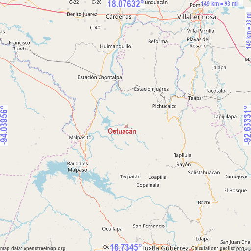
Ostuacán GPS coordinates[2]
17° 24' 23.904" North, 93° 20' 11.148" West
| Map corner | latitude | longitude |
|---|---|---|
| Upper-left | 18.07632°, | -94.03956° |
| Center: | 17.40664°, | -93.33643° |
| Lower-right: | 16.7345°, | -92.63331° |
| Map W x H: | 149.2×149.2 km | = 92.7×92.7mi |
| max Lat: | 32.7° ⇑84.1% North |
| Ostuacán: | 17.40664° |
| min Lat: | ⇓15.9% South 14.53588° |
| min Long | Ostuacán | max Long |
| -117.105° | -93.33643° | -86.73105° |
| W 87%⇐ | ⇒13% E |
Elevation
Elevation of Ostuacán is 132 m = 433 ft, and this is 1121.7 m = 3680 ft below average elevation for this country.
| Max E: |
3497 m = 11473 ft | 77.9% |
| Avg. | 1253.7 m = 4113 ft | |
| Ostuacán | 132 m = 433 ft | |
Min E: |
-1 m = -3 ft | 22.1% |
See also: Mexico elevation on elevation.city.
Geographical zone
Ostuacán is located in North Torrid zone (between Equator and Tropic of Cancer). Distance of this Northern Tropic circle is 670.5 km =416.6 mi to North.| Distance of | km | miles | from Ostuacán |
|---|---|---|---|
| North Pole | 8071.6 | 5015.5 | to North |
| Arctic Circle | 5465.7 | 3396.2 | to North |
| Tropic Cancer | 670.5 | 416.6 | to North |
| Equator | 1935.4 | 1202.6 | to South |


Nearby cities:
15 places around Ostuacán: (largest is in red/bold)
• Adolfo Ruiz Cortines
13.8 km =8.6 mi,  205°
205°
• Catedral de Chiapas
5.7 km =3.5 mi,  47°
47°
• Lindavista
16.8 km =10.4 mi,  295°
295°
• Naranjo
18 km =11.2 mi,  137°
137°
• Nuevo Juan del Grijalva
4.4 km =2.7 mi, 301°
• Nuevo Xochimilco
6.3 km =3.9 mi,  326°
326°
• Plan de Ayala
17.7 km =11 mi,  294°
294°
• Platanar Arriba 1ra. Sección A (La Florida)
16.9 km =10.5 mi,  14°
14°
• Rivera el Viejo Carmen
15.1 km =9.4 mi,  153°
153°
• San José Maspac
12.6 km =7.8 mi,  167°
167°
• San Miguel la Sardina
12.6 km =7.8 mi,  187°
187°
• Sunuapa
13.6 km =8.5 mi, 46°
• Vicente Guerrero
18.7 km =11.6 mi,  133°
133°
• Viejo Nicapa
13.5 km =8.4 mi,  81°
81°
• Xochimilco (Reymundo Enríquez)
4 km =2.5 mi,  120°
120°
Sources, notices
• [Note1] Compared only with cities in Mexico existing in our database
• [Src1] Map data: © OpenStreetMap contributors (CC-BY-SA)
• [Src2] Other city data from geonames.org with taken over terms of usage.
• [Src3] Geographical zone / Annual Mean Temperature by Robert A. Rohde @ Wikipedia
