Vicente Guerrero geodata
Vicente Guerrero (Chiapas) is a populated place; located in Mexico in America/Mexico_City (GMT-6) time zone. With population of 678 people, there are 12811 cities with bigger population in this country. Compared to other cities in Mexico, 85.4% of cities are located further ↑North; 87.6% of cities are located further ←West and 68.7% of cities have higher elevation than Vicente Guerrero. Note1


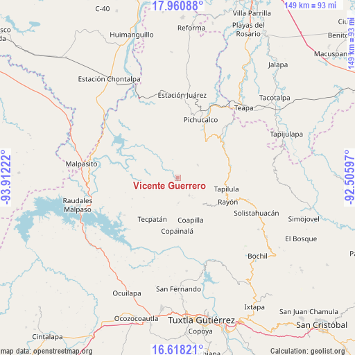
Vicente Guerrero GPS coordinates[2]
17° 17' 26.772" North, 93° 12' 32.724" West
| Map corner | latitude | longitude |
|---|---|---|
| Upper-left | 17.96088°, | -93.91222° |
| Center: | 17.29077°, | -93.20909° |
| Lower-right: | 16.61821°, | -92.50597° |
| Map W x H: | 149.3×149.3 km | = 92.8×92.8mi |
| max Lat: | 32.7° ⇑85.4% North |
| Vicente Guerrero: | 17.29077° |
| min Lat: | ⇓14.6% South 14.53588° |
| min Long | Vicente Guerrer | max Long |
| -117.105° | -93.20909° | -86.73105° |
| W 87.6%⇐ | ⇒12.4% E |
Elevation
Elevation of Vicente Guerrero is 486 m = 1594 ft, and this is 767.7 m = 2519 ft below average elevation for this country.
| Max E: |
3497 m = 11473 ft | 68.7% |
| Avg. | 1253.7 m = 4113 ft | |
| Vicente Guerrero | 486 m = 1594 ft | |
Min E: |
-1 m = -3 ft | 31.3% |
See also: Mexico elevation on elevation.city.
Geographical zone
Vicente Guerrero is located in North Torrid zone (between Equator and Tropic of Cancer). Distance of this Northern Tropic circle is 683.4 km =424.6 mi to North.| Distance of | km | miles | from Vicente Guerrero |
|---|---|---|---|
| North Pole | 8084.5 | 5023.5 | to North |
| Arctic Circle | 5478.6 | 3404.2 | to North |
| Tropic Cancer | 683.4 | 424.6 | to North |
| Equator | 1922.6 | 1194.6 | to South |


Nearby cities:
15 places around Vicente Guerrero: (largest is in red/bold)
• Campeche
14 km =8.7 mi,  209°
209°
• Chapultenango
10.1 km =6.3 mi,  56°
56°
• Guadalupe Victoria
6.2 km =3.9 mi, 55°
• Naranjo
1.3 km =0.8 mi,  255°
255°
• Ocotepec
8.6 km =5.3 mi,  146°
146°
• Rivera el Viejo Carmen
6.9 km =4.3 mi, 264°
• Río Negro
12.4 km =7.7 mi,  67°
67°
• San Andrés Carrizal
10.9 km =6.8 mi,  139°
139°
• San Antonio Poyono
8.4 km =5.2 mi,  174°
174°
• San Francisco Ocotal
10.4 km =6.5 mi, 143°
• San José Maspac
10.8 km =6.7 mi,  273°
273°
• San Miguel la Sardina
15.2 km =9.4 mi, 271°
• San Pablo Huacano
10.6 km =6.6 mi,  179°
179°
• Viejo Nicapa
14.9 km =9.3 mi,  359°
359°
• Xochimilco (Reymundo Enríquez)
14.8 km =9.2 mi,  317°
317°
Sources, notices
• [Note1] Compared only with cities in Mexico existing in our database
• [Src1] Map data: © OpenStreetMap contributors (CC-BY-SA)
• [Src2] Other city data from geonames.org with taken over terms of usage.
• [Src3] Geographical zone / Annual Mean Temperature by Robert A. Rohde @ Wikipedia
