Viejo Nicapa geodata
Viejo Nicapa (Chiapas) is a populated place; located in Mexico in America/Mexico_City (GMT-6) time zone. With population of 592 people, there are 14508 cities with bigger population in this country. Compared to other cities in Mexico, 83.9% of cities are located further ↑North; 87.5% of cities are located further ←West and 72.4% of cities have higher elevation than Viejo Nicapa. Note1


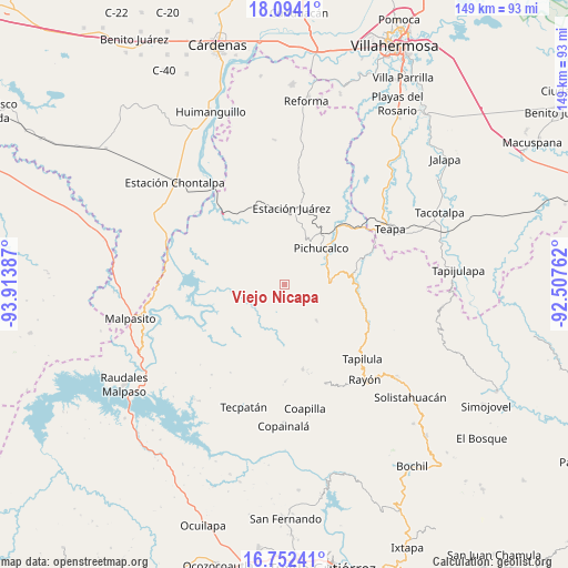
Viejo Nicapa GPS coordinates[2]
17° 25' 28.164" North, 93° 12' 38.664" West
| Map corner | latitude | longitude |
|---|---|---|
| Upper-left | 18.0941°, | -93.91387° |
| Center: | 17.42449°, | -93.21074° |
| Lower-right: | 16.75241°, | -92.50762° |
| Map W x H: | 149.2×149.2 km | = 92.7×92.7mi |
| max Lat: | 32.7° ⇑83.9% North |
| Viejo Nicapa: | 17.42449° |
| min Lat: | ⇓16.1% South 14.53588° |
| min Long | Viejo Nicapa | max Long |
| -117.105° | -93.21074° | -86.73105° |
| W 87.5%⇐ | ⇒12.5% E |
Elevation
Elevation of Viejo Nicapa is 317 m = 1040 ft, and this is 936.7 m = 3073 ft below average elevation for this country.
| Max E: |
3497 m = 11473 ft | 72.4% |
| Avg. | 1253.7 m = 4113 ft | |
| Viejo Nicapa | 317 m = 1040 ft | |
Min E: |
-1 m = -3 ft | 27.6% |
See also: Mexico elevation on elevation.city.
Geographical zone
Viejo Nicapa is located in North Torrid zone (between Equator and Tropic of Cancer). Distance of this Northern Tropic circle is 668.5 km =415.4 mi to North.| Distance of | km | miles | from Viejo Nicapa |
|---|---|---|---|
| North Pole | 8069.6 | 5014.2 | to North |
| Arctic Circle | 5463.8 | 3395 | to North |
| Tropic Cancer | 668.5 | 415.4 | to North |
| Equator | 1937.4 | 1203.8 | to South |


Nearby cities:
15 places around Viejo Nicapa: (largest is in red/bold)
• Catedral de Chiapas
9.3 km =5.8 mi,  281°
281°
• Chapultenango
12.6 km =7.8 mi,  137°
137°
• Emiliano Zapata
12.3 km =7.6 mi,  71°
71°
• Guadalupe Victoria
12.5 km =7.8 mi,  155°
155°
• Ixtacomitán
12.1 km =7.5 mi,  86°
86°
• Napana
15.2 km =9.4 mi,  49°
49°
• Naranjo
15.2 km =9.4 mi,  184°
184°
• Ostuacán
13.5 km =8.4 mi,  261°
261°
• Pichucalco
13.8 km =8.6 mi, 46°
• Rivera el Viejo Carmen
16.9 km =10.5 mi,  203°
203°
• Río Negro
15.4 km =9.6 mi,  130°
130°
• Sunuapa
8.3 km =5.2 mi,  334°
334°
• Tectuapan
6 km =3.7 mi, 65°
• Vicente Guerrero
14.9 km =9.3 mi, 179°
• Xochimilco (Reymundo Enríquez)
10.7 km =6.6 mi,  248°
248°
Sources, notices
• [Note1] Compared only with cities in Mexico existing in our database
• [Src1] Map data: © OpenStreetMap contributors (CC-BY-SA)
• [Src2] Other city data from geonames.org with taken over terms of usage.
• [Src3] Geographical zone / Annual Mean Temperature by Robert A. Rohde @ Wikipedia
