Nopalucán geodata
Nopalucán (Puebla) is a seat of a second-order administrative division; located in Mexico in America/Mexico_City (GMT-6) time zone. With population of 6,789 people, there are 1375 cities with bigger population in this country. Compared to other cities in Mexico, 60.7% of cities are located further ↑North; 65.8% of cities are located further ←West and 91.5% of cities have lower elevation than Nopalucán. Note1


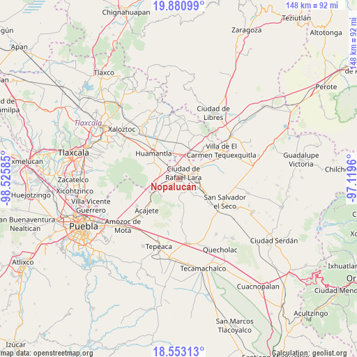
Nopalucán GPS coordinates[2]
19° 13' 6.24" North, 97° 49' 21.792" West
| Map corner | latitude | longitude |
|---|---|---|
| Upper-left | 19.88099°, | -98.52585° |
| Center: | 19.2184°, | -97.82272° |
| Lower-right: | 18.55313°, | -97.1196° |
| Map W x H: | 147.6×147.6 km | = 91.7×91.7mi |
| max Lat: | 32.7° ⇑60.7% North |
| Nopalucán: | 19.2184° |
| min Lat: | ⇓39.3% South 14.53588° |
| min Long | Nopalucán | max Long |
| -117.105° | -97.82272° | -86.73105° |
| W 65.8%⇐ | ⇒34.2% E |
Elevation
Elevation of Nopalucán is 2460 m = 8071 ft, and this is 1206.3 m = 3958 ft above average elevation for this country.
| Max E: |
3497 m = 11473 ft | 8.5% |
| Nopalucán | 2460 m 8071 ft | |
| Avg. | 1253.7 m = 4113 ft | |
Min E: |
-1 m = -3 ft | 91.5% |
See also: Mexico elevation on elevation.city.
Geographical zone
Nopalucán is located in North Torrid zone (between Equator and Tropic of Cancer). Distance of this Northern Tropic circle is 469 km =291.4 mi to North.| Distance of | km | miles | from Nopalucán |
|---|---|---|---|
| North Pole | 7870.2 | 4890.3 | to North |
| Arctic Circle | 5264.3 | 3271.1 | to North |
| Tropic Cancer | 469 | 291.4 | to North |
| Equator | 2136.9 | 1327.8 | to South |


Nearby cities:
15 places around Nopalucán: (largest is in red/bold)
• Colonia Benito Juárez
8.1 km =5 mi,  150°
150°
• Colonia Obrera
2.9 km =1.8 mi,  65°
65°
• Eréndira
9.4 km =5.8 mi,  140°
140°
• Grajales
2.3 km =1.4 mi,  62°
62°
• Ixtenco
8.3 km =5.2 mi,  296°
296°
• Juan de la Granja
1.5 km =0.9 mi,  78°
78°
• Manuel Ávila Camacho (La Cima)
10.2 km =6.3 mi,  172°
172°
• Máximo Serdán
5 km =3.1 mi,  353°
353°
• San José Chiapa
6.4 km =4 mi, 66°
• San José Ozumba
10 km =6.2 mi, 80°
• San Juan Bautista Mier
4.7 km =2.9 mi,  294°
294°
• Santa Cuz del Bosque
9.4 km =5.8 mi,  186°
186°
• Santa María Ixtiyucán
3.7 km =2.3 mi,  160°
160°
• Unidad Grajales INFONAVIT
2.8 km =1.7 mi,  26°
26°
• Zitlaltépec
9 km =5.6 mi,  259°
259°
Sources, notices
• [Note1] Compared only with cities in Mexico existing in our database
• [Src1] Map data: © OpenStreetMap contributors (CC-BY-SA)
• [Src2] Other city data from geonames.org with taken over terms of usage.
• [Src3] Geographical zone / Annual Mean Temperature by Robert A. Rohde @ Wikipedia
