Colonia Benito Juárez geodata
Colonia Benito Juárez (Puebla) is a populated place; located in Mexico in America/Mexico_City (GMT-6) time zone. With population of 720 people, there are 12117 cities with bigger population in this country. Compared to other cities in Mexico, 62.1% of cities are located further ↑North; 66.3% of cities are located further ←West and 89.3% of cities have lower elevation than Colonia Benito Juárez. Note1
Current local time in Colonia Benito Juárez:
06:59 AM, WednesdayDifference from your time zone: hours


Colonia Benito Juárez GPS coordinates[2]
19° 9' 17.856" North, 97° 47' 7.404" West
| Map corner | latitude | longitude |
|---|---|---|
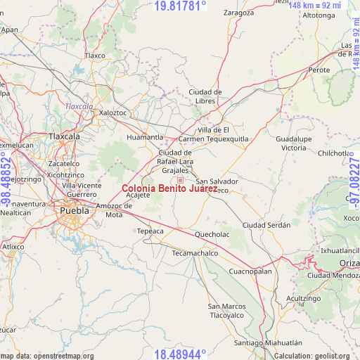
| Upper-left | 19.81781°, | -98.48852° |
| Center: | 19.15496°, | -97.78539° |
| Lower-right: | 18.48944°, | -97.08227° |
| Map W x H: | 147.7×147.7 km | = 91.8×91.8mi |
| max Lat: | 32.7° ⇑62.1% North |
| Colonia Benito Juárez: | 19.15496° |
| min Lat: | ⇓37.9% South 14.53588° |
| min Long | Colonia Benito | max Long |
| -117.105° | -97.78539° | -86.73105° |
| W 66.3%⇐ | ⇒33.7% E |
Elevation
Elevation of Colonia Benito Juárez is 2382 m = 7815 ft, and this is 1128.3 m = 3702 ft above average elevation for this country.
| Max E: |
3497 m = 11473 ft | 10.7% |
| Colonia Benito Juárez | 2382 m 7815 ft | |
| Avg. | 1253.7 m = 4113 ft | |
Min E: |
-1 m = -3 ft | 89.3% |
See also: Mexico elevation on elevation.city.
Geographical zone
Colonia Benito Juárez is located in North Torrid zone (between Equator and Tropic of Cancer). Distance of this Northern Tropic circle is 476.1 km =295.8 mi to North.| Distance of | km | miles | from Colonia Benito Juárez |
|---|---|---|---|
| North Pole | 7877.2 | 4894.7 | to North |
| Arctic Circle | 5271.3 | 3275.4 | to North |
| Tropic Cancer | 476.1 | 295.8 | to North |
| Equator | 2129.8 | 1323.4 | to South |


Nearby cities:
15 places around Colonia Benito Juárez: (largest is in red/bold)
• Colonia Obrera
8.4 km =5.2 mi,  351°
351°
• Eréndira
2 km =1.2 mi,  96°
96°
• Grajales
8.3 km =5.2 mi, 347°
• Hernández
7 km =4.3 mi,  192°
192°
• Juan de la Granja
7.8 km =4.8 mi,  341°
341°
• La Ermita
4 km =2.5 mi,  183°
183°
• Libertad Álvaro Obregón
3 km =1.9 mi,  140°
140°
• Manuel Ávila Camacho (La Cima)
4 km =2.5 mi,  221°
221°
• Mazapiltepec
9.5 km =5.9 mi,  114°
114°
• Nopalucán
8.1 km =5 mi,  330°
330°
• San Mateo Soltepec
6.8 km =4.2 mi,  157°
157°
• Santa Cuz del Bosque
5.5 km =3.4 mi,  245°
245°
• Santa María Ixtiyucán
4.4 km =2.7 mi,  322°
322°
• Soltepec
8.9 km =5.5 mi,  115°
115°
• Vista Hermosa
7 km =4.3 mi,  125°
125°
Sources, notices
• [Note1] Compared only with cities in Mexico existing in our database
• [Src1] Map data: © OpenStreetMap contributors (CC-BY-SA)
• [Src2] Other city data from geonames.org with taken over terms of usage.
• [Src3] Geographical zone / Annual Mean Temperature by Robert A. Rohde @ Wikipedia
