Máximo Serdán geodata
Máximo Serdán (Puebla) is a populated place; located in Mexico in America/Mexico_City (GMT-6) time zone. With population of 3,998 people, there are 2282 cities with bigger population in this country. Compared to other cities in Mexico, 59.6% of cities are located further ↑North; 65.7% of cities are located further ←West and 89.9% of cities have lower elevation than Máximo Serdán. Note1


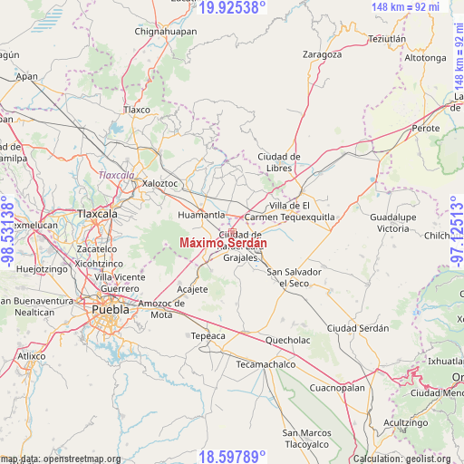
Máximo Serdán GPS coordinates[2]
19° 15' 46.728" North, 97° 49' 41.7" West
| Map corner | latitude | longitude |
|---|---|---|
| Upper-left | 19.92538°, | -98.53138° |
| Center: | 19.26298°, | -97.82825° |
| Lower-right: | 18.59789°, | -97.12513° |
| Map W x H: | 147.6×147.6 km | = 91.7×91.7mi |
| max Lat: | 32.7° ⇑59.6% North |
| Máximo Serdán: | 19.26298° |
| min Lat: | ⇓40.4% South 14.53588° |
| min Long | Máximo Serdán | max Long |
| -117.105° | -97.82825° | -86.73105° |
| W 65.7%⇐ | ⇒34.3% E |
Elevation
Elevation of Máximo Serdán is 2402 m = 7881 ft, and this is 1148.3 m = 3767 ft above average elevation for this country.
| Max E: |
3497 m = 11473 ft | 10.1% |
| Máximo Serdán | 2402 m 7881 ft | |
| Avg. | 1253.7 m = 4113 ft | |
Min E: |
-1 m = -3 ft | 89.9% |
See also: Mexico elevation on elevation.city.
Geographical zone
Máximo Serdán is located in North Torrid zone (between Equator and Tropic of Cancer). Distance of this Northern Tropic circle is 464.1 km =288.4 mi to North.| Distance of | km | miles | from Máximo Serdán |
|---|---|---|---|
| North Pole | 7865.2 | 4887.2 | to North |
| Arctic Circle | 5259.3 | 3268 | to North |
| Tropic Cancer | 464.1 | 288.4 | to North |
| Equator | 2141.8 | 1330.9 | to South |


Nearby cities:
15 places around Máximo Serdán: (largest is in red/bold)
• Colonia Obrera
4.9 km =3 mi,  139°
139°
• Cuapiaxtla
7.2 km =4.5 mi,  59°
59°
• Grajales
4.7 km =2.9 mi,  145°
145°
• Ignacio Zaragoza
10.3 km =6.4 mi,  288°
288°
• Ixtenco
7 km =4.3 mi,  259°
259°
• Juan de la Granja
5.1 km =3.2 mi,  156°
156°
• Nopalucán
5 km =3.1 mi,  173°
173°
• Plan de Ayala
10.8 km =6.7 mi, 61°
• San José Chiapa
6.9 km =4.3 mi,  110°
110°
• San José Ozumba
11 km =6.8 mi, 107°
• San José Xicohténcatl
10.2 km =6.3 mi,  358°
358°
• San Juan Bautista Mier
4.7 km =2.9 mi,  230°
230°
• Santa María Ixtiyucán
8.7 km =5.4 mi, 167°
• Unidad Grajales INFONAVIT
3 km =1.9 mi, 142°
• Zitlaltépec
10.6 km =6.6 mi, 231°
Sources, notices
• [Note1] Compared only with cities in Mexico existing in our database
• [Src1] Map data: © OpenStreetMap contributors (CC-BY-SA)
• [Src2] Other city data from geonames.org with taken over terms of usage.
• [Src3] Geographical zone / Annual Mean Temperature by Robert A. Rohde @ Wikipedia
