Napana geodata
Napana (Chiapas) is a populated place; located in Mexico in America/Mexico_City (GMT-6) time zone. With population of 973 people, there are 8931 cities with bigger population in this country. Compared to other cities in Mexico, 83% of cities are located further ↑North; 88.1% of cities are located further ←West and 82.6% of cities have higher elevation than Napana. Note1


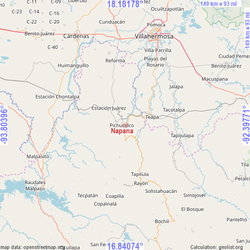
Napana GPS coordinates[2]
17° 30' 45" North, 93° 6' 2.988" West
| Map corner | latitude | longitude |
|---|---|---|
| Upper-left | 18.18178°, | -93.80396° |
| Center: | 17.5125°, | -93.10083° |
| Lower-right: | 16.84074°, | -92.39771° |
| Map W x H: | 149.1×149.1 km | = 92.6×92.6mi |
| max Lat: | 32.7° ⇑83% North |
| Napana: | 17.5125° |
| min Lat: | ⇓17% South 14.53588° |
| min Long | Napana | max Long |
| -117.105° | -93.10083° | -86.73105° |
| W 88.1%⇐ | ⇒11.9% E |
Elevation
Elevation of Napana is 64 m = 210 ft, and this is 1189.7 m = 3903 ft below average elevation for this country.
| Max E: |
3497 m = 11473 ft | 82.6% |
| Avg. | 1253.7 m = 4113 ft | |
| Napana | 64 m = 210 ft | |
Min E: |
-1 m = -3 ft | 17.4% |
See also: Mexico elevation on elevation.city.
Geographical zone
Napana is located in North Torrid zone (between Equator and Tropic of Cancer). Distance of this Northern Tropic circle is 658.7 km =409.3 mi to North.| Distance of | km | miles | from Napana |
|---|---|---|---|
| North Pole | 8059.9 | 5008.2 | to North |
| Arctic Circle | 5454 | 3389 | to North |
| Tropic Cancer | 658.7 | 409.3 | to North |
| Equator | 1947.2 | 1209.9 | to South |


Nearby cities:
15 places around Napana: (largest is in red/bold)
• Chapultepec
14.8 km =9.2 mi,  66°
66°
• Doctor Belisario Domínguez
11.4 km =7.1 mi,  333°
333°
• Emiliano Zapata
5.9 km =3.7 mi,  179°
179°
• Ignacio Allende 2da. Sección
12.7 km =7.9 mi, 69°
• Ixtacomitán
9.1 km =5.7 mi, 177°
• Ixtapangajoya
10.6 km =6.6 mi,  98°
98°
• Juan Aldama
13.2 km =8.2 mi,  35°
35°
• Juárez
14.3 km =8.9 mi,  316°
316°
• Mariano Abasolo
14.5 km =9 mi, 74°
• Mariano Matamoros Segunda Sección
3.8 km =2.4 mi,  341°
341°
• Nuevo Nicapa
13.9 km =8.6 mi,  12°
12°
• Pichucalco
1.6 km =1 mi,  260°
260°
• Solosuchiapa
11.7 km =7.3 mi,  141°
141°
• Tectuapan
9.6 km =6 mi,  220°
220°
• Viejo Nicapa
15.2 km =9.4 mi,  229°
229°
Sources, notices
• [Note1] Compared only with cities in Mexico existing in our database
• [Src1] Map data: © OpenStreetMap contributors (CC-BY-SA)
• [Src2] Other city data from geonames.org with taken over terms of usage.
• [Src3] Geographical zone / Annual Mean Temperature by Robert A. Rohde @ Wikipedia
