Comalapa geodata
Comalapa (Chiapas) is a seat of a second-order administrative division; located in Mexico in America/Mexico_City (GMT-6) time zone. With population of 18,704 people, there are 525 cities with bigger population in this country. Compared to other cities in Mexico, 98.3% of cities are located further ↑North; 94.6% of cities are located further ←West and 65.6% of cities have higher elevation than Comalapa. Note1


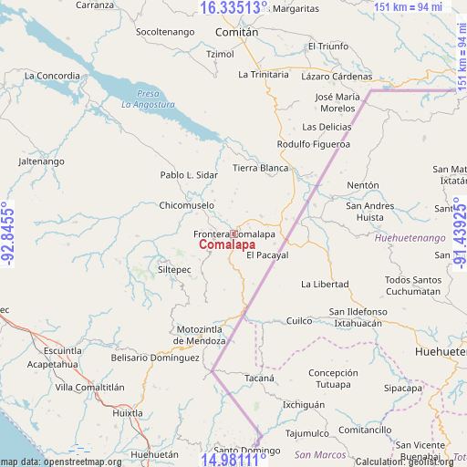
Comalapa GPS coordinates[2]
15° 39' 33.264" North, 92° 8' 32.532" West
| Map corner | latitude | longitude |
|---|---|---|
| Upper-left | 16.33513°, | -92.8455° |
| Center: | 15.65924°, | -92.14237° |
| Lower-right: | 14.98111°, | -91.43925° |
| Map W x H: | 150.6×150.6 km | = 93.6×93.6mi |
| max Lat: | 32.7° ⇑98.3% North |
| Comalapa: | 15.65924° |
| min Lat: | ⇓1.7% South 14.53588° |
| min Long | Comalapa | max Long |
| -117.105° | -92.14237° | -86.73105° |
| W 94.6%⇐ | ⇒5.4% E |
Elevation
Elevation of Comalapa is 657 m = 2156 ft, and this is 596.7 m = 1958 ft below average elevation for this country.
| Max E: |
3497 m = 11473 ft | 65.6% |
| Avg. | 1253.7 m = 4113 ft | |
| Comalapa | 657 m = 2156 ft | |
Min E: |
-1 m = -3 ft | 34.4% |
See also: Mexico elevation on elevation.city.
Geographical zone
Comalapa is located in North Torrid zone (between Equator and Tropic of Cancer). Distance of this Northern Tropic circle is 864.8 km =537.4 mi to North.| Distance of | km | miles | from Comalapa |
|---|---|---|---|
| North Pole | 8265.9 | 5136.2 | to North |
| Arctic Circle | 5660 | 3517 | to North |
| Tropic Cancer | 864.8 | 537.4 | to North |
| Equator | 1741.1 | 1081.9 | to South |


Nearby cities:
15 places around Comalapa: (largest is in red/bold)
• Agua Zarca
2.8 km =1.7 mi,  185°
185°
• Bellavista del Norte
1.9 km =1.2 mi,  294°
294°
• El Anonal
3.5 km =2.2 mi,  23°
23°
• El Portal
5.4 km =3.4 mi,  68°
68°
• El Triunfo de las Tres Maravillas
2 km =1.2 mi,  227°
227°
• Guadalupe Grijalva
5 km =3.1 mi,  332°
332°
• La Lima
1.5 km =0.9 mi, 68°
• La Sabinada
3.8 km =2.4 mi,  342°
342°
• Las Chicharras
7.4 km =4.6 mi,  280°
280°
• Nueva Morelia
4.6 km =2.9 mi,  183°
183°
• Nuevo México
5.4 km =3.4 mi,  54°
54°
• Río Guerrero
8.5 km =5.3 mi, 190°
• San José las Chicharras
7.1 km =4.4 mi,  255°
255°
• Santa Rosa
8.2 km =5.1 mi,  29°
29°
• Veinticuatro de Febrero
7.4 km =4.6 mi,  322°
322°
Sources, notices
• [Note1] Compared only with cities in Mexico existing in our database
• [Src1] Map data: © OpenStreetMap contributors (CC-BY-SA)
• [Src2] Other city data from geonames.org with taken over terms of usage.
• [Src3] Geographical zone / Annual Mean Temperature by Robert A. Rohde @ Wikipedia
