Mextepec geodata
Mextepec (State of Mexico) is a populated place; located in Mexico in America/Mexico_City (GMT-6) time zone. With population of 3,424 people, there are 2658 cities with bigger population in this country. Compared to other cities in Mexico, 54.9% of cities are located further ↑North; 62.5% of cities are located further →East and 95.4% of cities have lower elevation than Mextepec. Note1


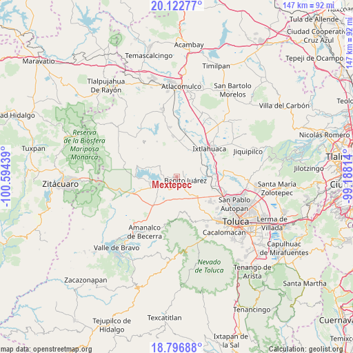
Mextepec GPS coordinates[2]
19° 27' 40.248" North, 99° 53' 28.536" West
| Map corner | latitude | longitude |
|---|---|---|
| Upper-left | 20.12277°, | -100.59439° |
| Center: | 19.46118°, | -99.89126° |
| Lower-right: | 18.79688°, | -99.18814° |
| Map W x H: | 147.4×147.4 km | = 91.6×91.6mi |
| max Lat: | 32.7° ⇑54.9% North |
| Mextepec: | 19.46118° |
| min Lat: | ⇓45.1% South 14.53588° |
| min Long | Mextepec | max Long |
| -117.105° | -99.89126° | -86.73105° |
| W 37.5%⇐ | ⇒62.5% E |
Elevation
Elevation of Mextepec is 2604 m = 8543 ft, and this is 1350.3 m = 4430 ft above average elevation for this country.
| Max E: |
3497 m = 11473 ft | 4.6% |
| Mextepec | 2604 m 8543 ft | |
| Avg. | 1253.7 m = 4113 ft | |
Min E: |
-1 m = -3 ft | 95.4% |
See also: Mexico elevation on elevation.city.
Geographical zone
Mextepec is located in North Torrid zone (between Equator and Tropic of Cancer). Distance of this Northern Tropic circle is 442 km =274.6 mi to North.| Distance of | km | miles | from Mextepec |
|---|---|---|---|
| North Pole | 7843.2 | 4873.5 | to North |
| Arctic Circle | 5237.3 | 3254.3 | to North |
| Tropic Cancer | 442 | 274.6 | to North |
| Equator | 2163.9 | 1344.6 | to South |


Nearby cities:
15 places around Mextepec: (largest is in red/bold)
• Barrio el Ocote
5.4 km =3.4 mi,  277°
277°
• Benito Juárez
4.7 km =2.9 mi,  123°
123°
• Casa Nueva (Casa Nueva Yebuciví)
4.2 km =2.6 mi,  321°
321°
• Colonia Doctor Gustavo Baz
6.5 km =4 mi,  209°
209°
• Hospital Propiedad (Dos Estrellas)
7.3 km =4.5 mi,  233°
233°
• Laguna de Tabernillas (El Resbaloso)
1.4 km =0.9 mi,  89°
89°
• Loma del Jacal (Loma de las Mangas)
2 km =1.2 mi,  61°
61°
• Loma del Salitre (Colonia Loma del Salitre)
5.5 km =3.4 mi,  98°
98°
• Ocoyotepec (Ocoyotepec Centro)
6.4 km =4 mi,  53°
53°
• Río Frío (Río Frío Yebuciví)
6.8 km =4.2 mi, 324°
• Salitrillo
5.3 km =3.3 mi,  125°
125°
• San Agustín las Tablas
6.7 km =4.2 mi, 96°
• San Joaquín del Monte
4.7 km =2.9 mi,  193°
193°
• Sitio Ejido
1.3 km =0.8 mi, 228°
• Venta de Ocotillos
7.2 km =4.5 mi, 279°
Sources, notices
• [Note1] Compared only with cities in Mexico existing in our database
• [Src1] Map data: © OpenStreetMap contributors (CC-BY-SA)
• [Src2] Other city data from geonames.org with taken over terms of usage.
• [Src3] Geographical zone / Annual Mean Temperature by Robert A. Rohde @ Wikipedia
