Méndez geodata
Méndez (Tamaulipas) is a seat of a second-order administrative division; located in Mexico in America/Monterrey (GMT-6) time zone. With population of 864 people, there are 10127 cities with bigger population in this country. Compared to other cities in Mexico, 92% of cities are located further ↓South; 56.2% of cities are located further ←West and 80.7% of cities have higher elevation than Méndez. Note1


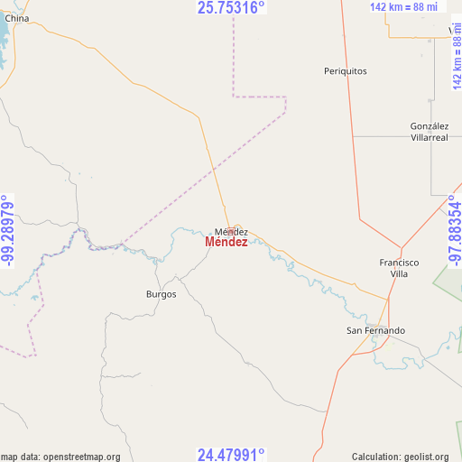
Méndez GPS coordinates[2]
25° 7' 5.484" North, 98° 35' 11.976" West
| Map corner | latitude | longitude |
|---|---|---|
| Upper-left | 25.75316°, | -99.28979° |
| Center: | 25.11819°, | -98.58666° |
| Lower-right: | 24.47991°, | -97.88354° |
| Map W x H: | 141.6×141.6 km | = 88×88mi |
| max Lat: | 32.7° ⇑8% North |
| Méndez: | 25.11819° |
| min Lat: | ⇓92% South 14.53588° |
| min Long | Méndez | max Long |
| -117.105° | -98.58666° | -86.73105° |
| W 56.2%⇐ | ⇒43.8% E |
Elevation
Elevation of Méndez is 85 m = 279 ft, and this is 1168.7 m = 3834 ft below average elevation for this country.
| Max E: |
3497 m = 11473 ft | 80.7% |
| Avg. | 1253.7 m = 4113 ft | |
| Méndez | 85 m = 279 ft | |
Min E: |
-1 m = -3 ft | 19.3% |
See also: Mexico elevation on elevation.city.
Geographical zone
Méndez is located in North temperate zone (between Tropic of Cancer and the Arctic Circle). Distance of this Northern Tropic circle is 187 km =116.2 mi to South.| Distance of | km | miles | from Méndez |
|---|---|---|---|
| North Pole | 7214.2 | 4482.7 | to North |
| Arctic Circle | 4608.3 | 2863.5 | to North |
| Tropic Cancer | 187 | 116.2 | to South |
| Equator | 2792.9 | 1735.4 | to South |


Nearby cities:
15 places around Méndez: (largest is in red/bold)
• Alfredo V. Bonfil
60.4 km =37.5 mi,  35°
35°
• Alfredo V. Bonfil
65.3 km =40.6 mi,  81°
81°
• Burgos
28.6 km =17.8 mi,  228°
228°
• Cruillas
40.5 km =25.2 mi,  172°
172°
• Cándido Aguilar
72.6 km =45.1 mi,  56°
56°
• División del Norte
65.4 km =40.6 mi,  122°
122°
• Emiliano Zapata (Ampliación San Germán)
53.7 km =33.4 mi,  93°
93°
• Guadalupe Victoria (El Norteño)
64.7 km =40.2 mi,  72°
72°
• La Loma
70.9 km =44.1 mi, 79°
• La Lomita
52.4 km =32.6 mi,  95°
95°
• San Carlos
69.6 km =43.2 mi,  211°
211°
• San Fernando
53.5 km =33.2 mi, 124°
• San Germán
67.8 km =42.1 mi, 80°
• San Nicolás
53.2 km =33.1 mi, 207°
• Santa Apolonia
84 km =52.2 mi,  46°
46°
Sources, notices
• [Note1] Compared only with cities in Mexico existing in our database
• [Src1] Map data: © OpenStreetMap contributors (CC-BY-SA)
• [Src2] Other city data from geonames.org with taken over terms of usage.
• [Src3] Geographical zone / Annual Mean Temperature by Robert A. Rohde @ Wikipedia
