San Carlos geodata
San Carlos (Tamaulipas) is a seat of a second-order administrative division; located in Mexico in America/Monterrey (GMT-6) time zone. With population of 1,116 people, there are 7786 cities with bigger population in this country. Compared to other cities in Mexico, 91% of cities are located further ↓South; 51.2% of cities are located further ←West and 69.3% of cities have higher elevation than San Carlos. Note1


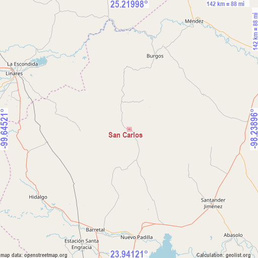
San Carlos GPS coordinates[2]
24° 34' 56.028" North, 98° 56' 31.488" West
| Map corner | latitude | longitude |
|---|---|---|
| Upper-left | 25.21998°, | -99.64521° |
| Center: | 24.58223°, | -98.94208° |
| Lower-right: | 23.94121°, | -98.23896° |
| Map W x H: | 142.2×142.2 km | = 88.4×88.4mi |
| max Lat: | 32.7° ⇑9% North |
| San Carlos: | 24.58223° |
| min Lat: | ⇓91% South 14.53588° |
| min Long | San Carlos | max Long |
| -117.105° | -98.94208° | -86.73105° |
| W 51.2%⇐ | ⇒48.8% E |
Elevation
Elevation of San Carlos is 453 m = 1486 ft, and this is 800.7 m = 2627 ft below average elevation for this country.
| Max E: |
3497 m = 11473 ft | 69.3% |
| Avg. | 1253.7 m = 4113 ft | |
| San Carlos | 453 m = 1486 ft | |
Min E: |
-1 m = -3 ft | 30.7% |
See also: Mexico elevation on elevation.city.
Geographical zone
San Carlos is located in North temperate zone (between Tropic of Cancer and the Arctic Circle). Distance of this Northern Tropic circle is 127.4 km =79.2 mi to South.| Distance of | km | miles | from San Carlos |
|---|---|---|---|
| North Pole | 7273.8 | 4519.7 | to North |
| Arctic Circle | 4667.9 | 2900.5 | to North |
| Tropic Cancer | 127.4 | 79.2 | to South |
| Equator | 2733.3 | 1698.4 | to South |


Nearby cities:
15 places around San Carlos: (largest is in red/bold)
• Barretal
58.5 km =36.4 mi,  198°
198°
• Burgos
43.1 km =26.8 mi,  19°
19°
• Cruillas
45.3 km =28.1 mi,  64°
64°
• Cruz y Cruz
59.3 km =36.8 mi, 204°
• El Barranco Azul
26.8 km =16.7 mi,  220°
220°
• El Saucillo
23 km =14.3 mi,  248°
248°
• Garza Valdez
45.5 km =28.3 mi,  261°
261°
• General Lucio Blanco
49.4 km =30.7 mi,  289°
289°
• Guadalupe Victoria
60 km =37.3 mi, 199°
• La Soledad
57.5 km =35.7 mi,  193°
193°
• Nueva Villa de Padilla
59.6 km =37 mi,  175°
175°
• Oyama
60.1 km =37.3 mi,  212°
212°
• San Nicolás
16.8 km =10.4 mi,  42°
42°
• Santander Jiménez
61.6 km =38.3 mi,  131°
131°
• Villagrán
56.9 km =35.4 mi, 257°
Sources, notices
• [Note1] Compared only with cities in Mexico existing in our database
• [Src1] Map data: © OpenStreetMap contributors (CC-BY-SA)
• [Src2] Other city data from geonames.org with taken over terms of usage.
• [Src3] Geographical zone / Annual Mean Temperature by Robert A. Rohde @ Wikipedia
