Mazapa geodata
Mazapa (Chiapas) is a seat of a second-order administrative division; located in Mexico in America/Mexico_City (GMT-6) time zone. With population of 1,580 people, there are 5466 cities with bigger population in this country. Compared to other cities in Mexico, 98.7% of cities are located further ↑North; 94.2% of cities are located further ←West and 58.3% of cities have higher elevation than Mazapa. Note1


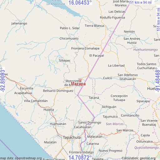
Mazapa GPS coordinates[2]
15° 23' 15.828" North, 92° 11' 16.08" West
| Map corner | latitude | longitude |
|---|---|---|
| Upper-left | 16.06453°, | -92.89093° |
| Center: | 15.38773°, | -92.1878° |
| Lower-right: | 14.70872°, | -91.48468° |
| Map W x H: | 150.8×150.8 km | = 93.7×93.7mi |
| max Lat: | 32.7° ⇑98.7% North |
| Mazapa: | 15.38773° |
| min Lat: | ⇓1.3% South 14.53588° |
| min Long | Mazapa | max Long |
| -117.105° | -92.1878° | -86.73105° |
| W 94.2%⇐ | ⇒5.8% E |
Elevation
Elevation of Mazapa is 1094 m = 3589 ft, and this is 159.7 m = 524 ft below average elevation for this country.
| Max E: |
3497 m = 11473 ft | 58.3% |
| Avg. | 1253.7 m = 4113 ft | |
| Mazapa | 1094 m = 3589 ft | |
Min E: |
-1 m = -3 ft | 41.7% |
See also: Mexico elevation on elevation.city.
Geographical zone
Mazapa is located in North Torrid zone (between Equator and Tropic of Cancer). Distance of this Northern Tropic circle is 895 km =556.1 mi to North.| Distance of | km | miles | from Mazapa |
|---|---|---|---|
| North Pole | 8296.1 | 5155 | to North |
| Arctic Circle | 5690.2 | 3535.7 | to North |
| Tropic Cancer | 895 | 556.1 | to North |
| Equator | 1711 | 1063.2 | to South |


Nearby cities:
15 places around Mazapa: (largest is in red/bold)
• Amatenango de la Frontera
9.3 km =5.8 mi,  56°
56°
• Bejucal de Ocampo
8.2 km =5.1 mi,  22°
22°
• Benito Juárez
13.6 km =8.5 mi,  259°
259°
• Canadá
7.9 km =4.9 mi,  328°
328°
• El Carrizal
12.2 km =7.6 mi,  279°
279°
• El Pino
7.9 km =4.9 mi, 18°
• El Porvenir de Velasco Suárez
12.5 km =7.8 mi,  307°
307°
• El Rodeo
13.3 km =8.3 mi,  316°
316°
• Granados Talcanaque
12.2 km =7.6 mi,  191°
191°
• Las Pilas
10.7 km =6.6 mi, 315°
• Malé
9.5 km =5.9 mi, 316°
• Motozintla
6.7 km =4.2 mi,  249°
249°
• Nueva Esperanza Uno
8.5 km =5.3 mi, 315°
• Ojo de Agua Centro
12.3 km =7.6 mi,  7°
7°
• Ojo de Agua Grande
11.7 km =7.3 mi, 13°
Sources, notices
• [Note1] Compared only with cities in Mexico existing in our database
• [Src1] Map data: © OpenStreetMap contributors (CC-BY-SA)
• [Src2] Other city data from geonames.org with taken over terms of usage.
• [Src3] Geographical zone / Annual Mean Temperature by Robert A. Rohde @ Wikipedia
