Benito Juárez geodata
Benito Juárez (Chiapas) is a populated place; located in Mexico in America/Mexico_City (GMT-6) time zone. With population of 766 people, there are 11432 cities with bigger population in this country. Compared to other cities in Mexico, 98.7% of cities are located further ↑North; 93.3% of cities are located further ←West and 77.9% of cities have lower elevation than Benito Juárez. Note1


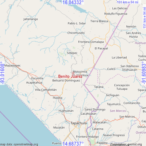
Benito Juárez GPS coordinates[2]
15° 21' 59.22" North, 92° 18' 46.62" West
| Map corner | latitude | longitude |
|---|---|---|
| Upper-left | 16.04332°, | -93.01608° |
| Center: | 15.36645°, | -92.31295° |
| Lower-right: | 14.68737°, | -91.60983° |
| Map W x H: | 150.8×150.8 km | = 93.7×93.7mi |
| max Lat: | 32.7° ⇑98.7% North |
| Benito Juárez: | 15.36645° |
| min Lat: | ⇓1.3% South 14.53588° |
| min Long | Benito Juárez | max Long |
| -117.105° | -92.31295° | -86.73105° |
| W 93.3%⇐ | ⇒6.7% E |
Elevation
Elevation of Benito Juárez is 2086 m = 6844 ft, and this is 832.3 m = 2731 ft above average elevation for this country.
| Max E: |
3497 m = 11473 ft | 22.1% |
| Benito Juárez | 2086 m 6844 ft | |
| Avg. | 1253.7 m = 4113 ft | |
Min E: |
-1 m = -3 ft | 77.9% |
See also: Mexico elevation on elevation.city.
Geographical zone
Benito Juárez is located in North Torrid zone (between Equator and Tropic of Cancer). Distance of this Northern Tropic circle is 897.3 km =557.6 mi to North.| Distance of | km | miles | from Benito Juárez |
|---|---|---|---|
| North Pole | 8298.5 | 5156.4 | to North |
| Arctic Circle | 5692.6 | 3537.2 | to North |
| Tropic Cancer | 897.3 | 557.6 | to North |
| Equator | 1708.6 | 1061.7 | to South |


Nearby cities:
15 places around Benito Juárez: (largest is in red/bold)
• Belisario Domínguez
10.4 km =6.5 mi,  224°
224°
• Berriozábal
12.2 km =7.6 mi,  165°
165°
• Buenavista
6.5 km =4 mi,  182°
182°
• Cambil
6.9 km =4.3 mi,  353°
353°
• El Carrizal
4.5 km =2.8 mi,  17°
17°
• El Porvenir de Velasco Suárez
10.7 km =6.6 mi, 19°
• Francisco I. Madero
11.8 km =7.3 mi,  257°
257°
• Las Pilas
11.6 km =7.2 mi,  30°
30°
• Las Salvias
9.6 km =6 mi,  5°
5°
• Llano Grande
11.5 km =7.1 mi, 180°
• Malé
11.5 km =7.1 mi,  36°
36°
• Miguel Alemán
11.2 km =7 mi,  269°
269°
• Motozintla
7.2 km =4.5 mi,  89°
89°
• Nueva Esperanza Uno
11.3 km =7 mi, 41°
• San José Ixtepec
7 km =4.3 mi, 256°
Sources, notices
• [Note1] Compared only with cities in Mexico existing in our database
• [Src1] Map data: © OpenStreetMap contributors (CC-BY-SA)
• [Src2] Other city data from geonames.org with taken over terms of usage.
• [Src3] Geographical zone / Annual Mean Temperature by Robert A. Rohde @ Wikipedia
