Canadá geodata
Canadá (Chiapas) is a populated place; located in Mexico in America/Mexico_City (GMT-6) time zone. With population of 641 people, there are 13506 cities with bigger population in this country. Compared to other cities in Mexico, 98.7% of cities are located further ↑North; 93.9% of cities are located further ←West and 96.9% of cities have lower elevation than Canadá. Note1


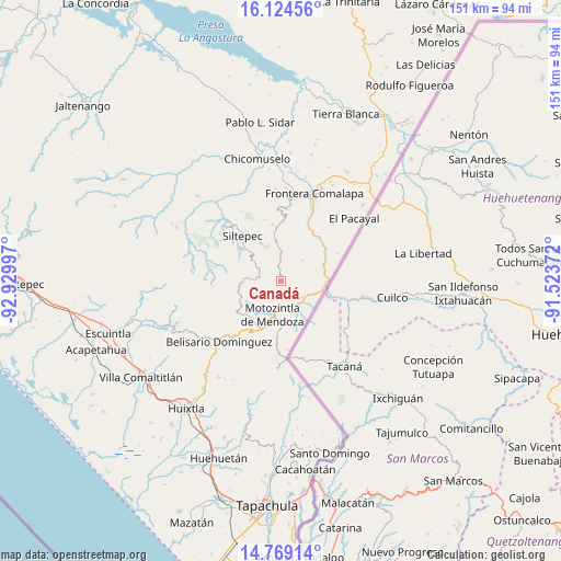
Canadá GPS coordinates[2]
15° 26' 52.656" North, 92° 13' 36.624" West
| Map corner | latitude | longitude |
|---|---|---|
| Upper-left | 16.12456°, | -92.92997° |
| Center: | 15.44796°, | -92.22684° |
| Lower-right: | 14.76914°, | -91.52372° |
| Map W x H: | 150.7×150.7 km | = 93.6×93.6mi |
| max Lat: | 32.7° ⇑98.7% North |
| Canadá: | 15.44796° |
| min Lat: | ⇓1.3% South 14.53588° |
| min Long | Canadá | max Long |
| -117.105° | -92.22684° | -86.73105° |
| W 93.9%⇐ | ⇒6.1% E |
Elevation
Elevation of Canadá is 2673 m = 8770 ft, and this is 1419.3 m = 4656 ft above average elevation for this country.
| Max E: |
3497 m = 11473 ft | 3.1% |
| Canadá | 2673 m 8770 ft | |
| Avg. | 1253.7 m = 4113 ft | |
Min E: |
-1 m = -3 ft | 96.9% |
See also: Mexico elevation on elevation.city.
Geographical zone
Canadá is located in North Torrid zone (between Equator and Tropic of Cancer). Distance of this Northern Tropic circle is 888.3 km =552 mi to North.| Distance of | km | miles | from Canadá |
|---|---|---|---|
| North Pole | 8289.4 | 5150.8 | to North |
| Arctic Circle | 5683.5 | 3531.6 | to North |
| Tropic Cancer | 888.3 | 552 | to North |
| Equator | 1717.7 | 1067.3 | to South |


Nearby cities:
15 places around Canadá: (largest is in red/bold)
• Bejucal de Ocampo
7.4 km =4.6 mi,  83°
83°
• El Palmar Grande
6.4 km =4 mi,  331°
331°
• El Palmarcito
8.8 km =5.5 mi,  335°
335°
• El Pino
6.7 km =4.2 mi, 83°
• El Porvenir de Velasco Suárez
5.8 km =3.6 mi,  279°
279°
• El Rodeo
5.8 km =3.6 mi,  301°
301°
• La Grandeza
6.9 km =4.3 mi,  0°
0°
• Las Pilas
3.4 km =2.1 mi,  285°
285°
• Las Salvias
8.4 km =5.2 mi,  273°
273°
• Malé
2.3 km =1.4 mi, 274°
• Mazapa
7.9 km =4.9 mi,  148°
148°
• Motozintla
9.2 km =5.7 mi,  192°
192°
• Nueva Esperanza Uno
1.9 km =1.2 mi,  250°
250°
• Ojo de Agua Centro
8 km =5 mi,  46°
46°
• Ojo de Agua Grande
8.4 km =5.2 mi,  55°
55°
Sources, notices
• [Note1] Compared only with cities in Mexico existing in our database
• [Src1] Map data: © OpenStreetMap contributors (CC-BY-SA)
• [Src2] Other city data from geonames.org with taken over terms of usage.
• [Src3] Geographical zone / Annual Mean Temperature by Robert A. Rohde @ Wikipedia
