Motozintla geodata
Motozintla (Chiapas) is a seat of a second-order administrative division; located in Mexico in America/Mexico_City (GMT-6) time zone. With population of 23,755 people, there are 428 cities with bigger population in this country. Compared to other cities in Mexico, 98.7% of cities are located further ↑North; 93.8% of cities are located further ←West and 53.6% of cities have higher elevation than Motozintla. Note1


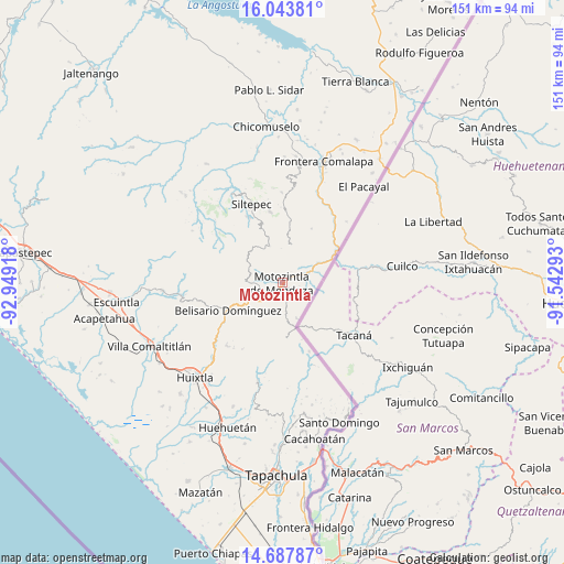
Motozintla GPS coordinates[2]
15° 22' 0.984" North, 92° 14' 45.78" West
| Map corner | latitude | longitude |
|---|---|---|
| Upper-left | 16.04381°, | -92.94918° |
| Center: | 15.36694°, | -92.24605° |
| Lower-right: | 14.68787°, | -91.54293° |
| Map W x H: | 150.8×150.8 km | = 93.7×93.7mi |
| max Lat: | 32.7° ⇑98.7% North |
| Motozintla: | 15.36694° |
| min Lat: | ⇓1.3% South 14.53588° |
| min Long | Motozintla | max Long |
| -117.105° | -92.24605° | -86.73105° |
| W 93.8%⇐ | ⇒6.2% E |
Elevation
Elevation of Motozintla is 1267 m = 4157 ft, and this is 13.3 m = 44 ft above average elevation for this country.
| Max E: |
3497 m = 11473 ft | 53.6% |
| Motozintla | 1267 m 4157 ft | |
| Avg. | 1253.7 m = 4113 ft | |
Min E: |
-1 m = -3 ft | 46.4% |
See also: Mexico elevation on elevation.city.
Geographical zone
Motozintla is located in North Torrid zone (between Equator and Tropic of Cancer). Distance of this Northern Tropic circle is 897.3 km =557.6 mi to North.| Distance of | km | miles | from Motozintla |
|---|---|---|---|
| North Pole | 8298.4 | 5156.4 | to North |
| Arctic Circle | 5692.5 | 3537.2 | to North |
| Tropic Cancer | 897.3 | 557.6 | to North |
| Equator | 1708.6 | 1061.7 | to South |


Nearby cities:
15 places around Motozintla: (largest is in red/bold)
• Benito Juárez
7.2 km =4.5 mi,  269°
269°
• Buenavista
9.9 km =6.2 mi,  228°
228°
• Cambil
10.5 km =6.5 mi,  310°
310°
• Canadá
9.2 km =5.7 mi,  12°
12°
• Checute
11.7 km =7.3 mi,  191°
191°
• El Carrizal
7.2 km =4.5 mi, 305°
• El Porvenir de Velasco Suárez
10.6 km =6.6 mi,  340°
340°
• El Rodeo
12.4 km =7.7 mi,  346°
346°
• Granados Talcanaque
10.4 km =6.5 mi,  158°
158°
• Las Pilas
10 km =6.2 mi, 352°
• Las Salvias
11.4 km =7.1 mi,  326°
326°
• Malé
9.2 km =5.7 mi,  358°
358°
• Mazapa
6.7 km =4.2 mi,  69°
69°
• Niquivil
12.5 km =7.8 mi, 163°
• Nueva Esperanza Uno
8.4 km =5.2 mi,  2°
2°
Sources, notices
• [Note1] Compared only with cities in Mexico existing in our database
• [Src1] Map data: © OpenStreetMap contributors (CC-BY-SA)
• [Src2] Other city data from geonames.org with taken over terms of usage.
• [Src3] Geographical zone / Annual Mean Temperature by Robert A. Rohde @ Wikipedia
