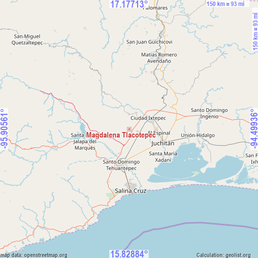
Magdalena Tlacotepec geodata
Magdalena Tlacotepec (Oaxaca) is a populated place; located in Mexico in America/Mexico_City (GMT-6) time zone. With population of 1,180 people, there are 7362 cities with bigger population in this country. Compared to other cities in Mexico, 94.3% of cities are located further ↑North; 84% of cities are located further ←West and 78.9% of cities have higher elevation than Magdalena Tlacotepec. Note1
Current local time in Magdalena Tlacotepec:
12:56 AM, WednesdayDifference from your time zone: hours


Magdalena Tlacotepec GPS coordinates[2]
16° 30' 14.976" North, 95° 12' 8.928" West
| Map corner | latitude | longitude |
|---|---|---|
| Upper-left | 17.17713°, | -95.90561° |
| Center: | 16.50416°, | -95.20248° |
| Lower-right: | 15.82884°, | -94.49936° |
| Map W x H: | 149.9×149.9 km | = 93.1×93.1mi |
| max Lat: | 32.7° ⇑94.3% North |
| Magdalena Tlacotepec: | 16.50416° |
| min Lat: | ⇓5.7% South 14.53588° |
| min Long | Magdalena Tlaco | max Long |
| -117.105° | -95.20248° | -86.73105° |
| W 84%⇐ | ⇒16% E |
Elevation
Elevation of Magdalena Tlacotepec is 114 m = 374 ft, and this is 1139.7 m = 3739 ft below average elevation for this country.
| Max E: |
3497 m = 11473 ft | 78.9% |
| Avg. | 1253.7 m = 4113 ft | |
| Magdalena Tlacotepec | 114 m = 374 ft | |
Min E: |
-1 m = -3 ft | 21.1% |
See also: Mexico elevation on elevation.city.
Geographical zone
Magdalena Tlacotepec is located in North Torrid zone (between Equator and Tropic of Cancer). Distance of this Northern Tropic circle is 770.8 km =479 mi to North.| Distance of | km | miles | from Magdalena Tlacotepec |
|---|---|---|---|
| North Pole | 8172 | 5077.8 | to North |
| Arctic Circle | 5566.1 | 3458.6 | to North |
| Tropic Cancer | 770.8 | 479 | to North |
| Equator | 1835.1 | 1140.3 | to South |


Nearby cities:
15 places around Magdalena Tlacotepec: (largest is in red/bold)
• Asunción Ixtaltepec
15.1 km =9.4 mi,  90°
90°
• Colonia Jordán
12.8 km =8 mi,  179°
179°
• Colonia San Luis
14.4 km =8.9 mi,  196°
196°
• El Espinal
17.5 km =10.9 mi,  96°
96°
• Ixtepec
12.2 km =7.6 mi,  59°
59°
• Juchitán de Zaragoza
20.9 km =13 mi,  111°
111°
• Puente Madera
14.7 km =9.1 mi,  171°
171°
• Rancho el Llano
11.1 km =6.9 mi,  153°
153°
• San Blas Atempa
19.4 km =12.1 mi,  187°
187°
• San Pedro Comitancillo
5.1 km =3.2 mi, 106°
• Santa María Mixtequilla
15.6 km =9.7 mi, 203°
• Santa Rosa
23.6 km =14.7 mi, 152°
• Santiago Laollaga
8.9 km =5.5 mi,  356°
356°
• Santo Domingo Chihuitán
10.6 km =6.6 mi,  23°
23°
• Santo Domingo Tehuantepec
20.4 km =12.7 mi, 191°
Sources, notices
• [Note1] Compared only with cities in Mexico existing in our database
• [Src1] Map data: © OpenStreetMap contributors (CC-BY-SA)
• [Src2] Other city data from geonames.org with taken over terms of usage.
• [Src3] Geographical zone / Annual Mean Temperature by Robert A. Rohde @ Wikipedia
