El Espinal geodata
El Espinal (Oaxaca) is a seat of a second-order administrative division; located in Mexico in America/Mexico_City (GMT-6) time zone. With population of 7,823 people, there are 1197 cities with bigger population in this country. Compared to other cities in Mexico, 94.5% of cities are located further ↑North; 84.5% of cities are located further ←West and 87% of cities have higher elevation than El Espinal. Note1


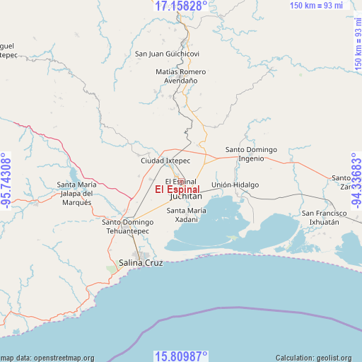
El Espinal GPS coordinates[2]
16° 29' 6.9" North, 95° 2' 23.82" West
| Map corner | latitude | longitude |
|---|---|---|
| Upper-left | 17.15828°, | -95.74308° |
| Center: | 16.48525°, | -95.03995° |
| Lower-right: | 15.80987°, | -94.33683° |
| Map W x H: | 149.9×149.9 km | = 93.1×93.1mi |
| max Lat: | 32.7° ⇑94.5% North |
| El Espinal: | 16.48525° |
| min Lat: | ⇓5.5% South 14.53588° |
| min Long | El Espinal | max Long |
| -117.105° | -95.03995° | -86.73105° |
| W 84.5%⇐ | ⇒15.5% E |
Elevation
Elevation of El Espinal is 34 m = 112 ft, and this is 1219.7 m = 4002 ft below average elevation for this country.
| Max E: |
3497 m = 11473 ft | 87% |
| Avg. | 1253.7 m = 4113 ft | |
| El Espinal | 34 m = 112 ft | |
Min E: |
-1 m = -3 ft | 13% |
See also: Mexico elevation on elevation.city.
Geographical zone
El Espinal is located in North Torrid zone (between Equator and Tropic of Cancer). Distance of this Northern Tropic circle is 772.9 km =480.3 mi to North.| Distance of | km | miles | from El Espinal |
|---|---|---|---|
| North Pole | 8174.1 | 5079.1 | to North |
| Arctic Circle | 5568.2 | 3459.9 | to North |
| Tropic Cancer | 772.9 | 480.3 | to North |
| Equator | 1833 | 1139 | to South |


Nearby cities:
15 places around El Espinal: (largest is in red/bold)
• Asunción Ixtaltepec
3 km =1.9 mi,  311°
311°
• Charis
21.8 km =13.5 mi,  195°
195°
• Colonia Jordán
20.3 km =12.6 mi,  238°
238°
• Ixtepec
10.8 km =6.7 mi,  320°
320°
• Juchitán de Zaragoza
5.9 km =3.7 mi,  158°
158°
• La Ventosa
12.3 km =7.6 mi,  53°
53°
• Magdalena Tlacotepec
17.5 km =10.9 mi,  276°
276°
• Puente Madera
19.6 km =12.2 mi,  230°
230°
• Rancho el Llano
14.6 km =9.1 mi, 237°
• San Pedro Comitancillo
12.4 km =7.7 mi,  273°
273°
• Santa María Xadani
13.9 km =8.6 mi,  170°
170°
• Santa Rosa
19.8 km =12.3 mi, 198°
• Santiago Laollaga
20.9 km =13 mi,  301°
301°
• Santo Domingo Chihuitán
17.7 km =11 mi, 311°
• Álvaro Obregón
21.3 km =13.2 mi,  192°
192°
Sources, notices
• [Note1] Compared only with cities in Mexico existing in our database
• [Src1] Map data: © OpenStreetMap contributors (CC-BY-SA)
• [Src2] Other city data from geonames.org with taken over terms of usage.
• [Src3] Geographical zone / Annual Mean Temperature by Robert A. Rohde @ Wikipedia
