Macuspana geodata
Macuspana (Tabasco) is a seat of a second-order administrative division; located in Mexico in America/Mexico_City (GMT-6) time zone. With population of 32,225 people, there are 314 cities with bigger population in this country. Compared to other cities in Mexico, 80.9% of cities are located further ↑North; 91.2% of cities are located further ←West and 94% of cities have higher elevation than Macuspana. Note1


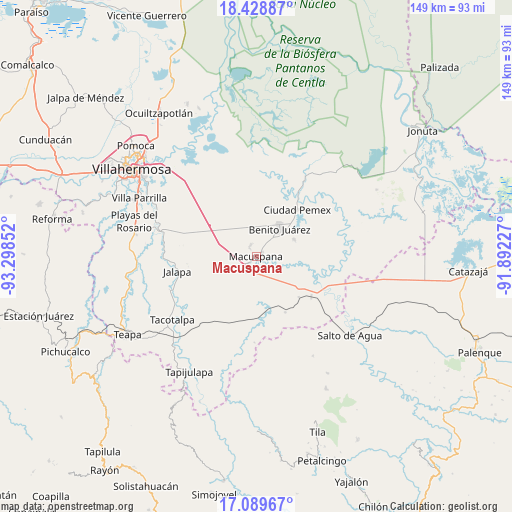
Macuspana GPS coordinates[2]
17° 45' 37.872" North, 92° 35' 43.404" West
| Map corner | latitude | longitude |
|---|---|---|
| Upper-left | 18.42887°, | -93.29852° |
| Center: | 17.76052°, | -92.59539° |
| Lower-right: | 17.08967°, | -91.89227° |
| Map W x H: | 148.9×148.9 km | = 92.5×92.5mi |
| max Lat: | 32.7° ⇑80.9% North |
| Macuspana: | 17.76052° |
| min Lat: | ⇓19.1% South 14.53588° |
| min Long | Macuspana | max Long |
| -117.105° | -92.59539° | -86.73105° |
| W 91.2%⇐ | ⇒8.8% E |
Elevation
Elevation of Macuspana is 15 m = 49 ft, and this is 1238.7 m = 4064 ft below average elevation for this country.
| Max E: |
3497 m = 11473 ft | 94% |
| Avg. | 1253.7 m = 4113 ft | |
| Macuspana | 15 m = 49 ft | |
Min E: |
-1 m = -3 ft | 6% |
See also: Mexico elevation on elevation.city.
Geographical zone
Macuspana is located in North Torrid zone (between Equator and Tropic of Cancer). Distance of this Northern Tropic circle is 631.1 km =392.1 mi to North.| Distance of | km | miles | from Macuspana |
|---|---|---|---|
| North Pole | 8032.3 | 4991 | to North |
| Arctic Circle | 5426.4 | 3371.8 | to North |
| Tropic Cancer | 631.1 | 392.1 | to North |
| Equator | 1974.8 | 1227.1 | to South |


Nearby cities:
15 places around Macuspana: (largest is in red/bold)
• Aquiles Serdán (San Fernando)
12.3 km =7.6 mi,  65°
65°
• Belén
3.6 km =2.2 mi,  331°
331°
• Buena Vista (Puxcatán)
4.2 km =2.6 mi,  218°
218°
• Buergos
7.9 km =4.9 mi,  320°
320°
• Cacahuatalillo
9.2 km =5.7 mi,  49°
49°
• Chichonal 3ra. Sección (La Capilla)
8.6 km =5.3 mi,  278°
278°
• Emiliano Zapata 2da. Sección
10.2 km =6.3 mi,  0°
0°
• Francisco Villa
12.1 km =7.5 mi,  160°
160°
• Ignacio Zaragoza (Los Ateos)
2.3 km =1.4 mi,  26°
26°
• La Escalera
11.8 km =7.3 mi,  38°
38°
• Lerdo de Tejada 2da. Sección
6.4 km =4 mi,  295°
295°
• Monte Largo 1ra. Sección
8.4 km =5.2 mi,  351°
351°
• Nicolás Bravo
5.5 km =3.4 mi,  205°
205°
• San Carlos
10.7 km =6.6 mi, 40°
• Veinte de Noviembre
9.6 km =6 mi, 3°
Sources, notices
• [Note1] Compared only with cities in Mexico existing in our database
• [Src1] Map data: © OpenStreetMap contributors (CC-BY-SA)
• [Src2] Other city data from geonames.org with taken over terms of usage.
• [Src3] Geographical zone / Annual Mean Temperature by Robert A. Rohde @ Wikipedia
