Belén geodata
Belén (Tabasco) is a populated place; located in Mexico in America/Mexico_City (GMT-6) time zone. With population of 5,892 people, there are 1581 cities with bigger population in this country. Compared to other cities in Mexico, 80.6% of cities are located further ↑North; 91.1% of cities are located further ←West and 90.4% of cities have higher elevation than Belén. Note1


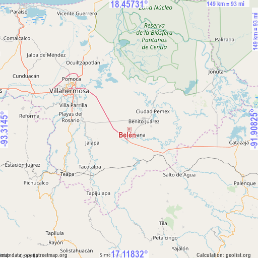
Belén GPS coordinates[2]
17° 47' 20.652" North, 92° 36' 40.932" West
| Map corner | latitude | longitude |
|---|---|---|
| Upper-left | 18.45731°, | -93.3145° |
| Center: | 17.78907°, | -92.61137° |
| Lower-right: | 17.11832°, | -91.90825° |
| Map W x H: | 148.9×148.9 km | = 92.5×92.5mi |
| max Lat: | 32.7° ⇑80.6% North |
| Belén: | 17.78907° |
| min Lat: | ⇓19.4% South 14.53588° |
| min Long | Belén | max Long |
| -117.105° | -92.61137° | -86.73105° |
| W 91.1%⇐ | ⇒8.9% E |
Elevation
Elevation of Belén is 23 m = 75 ft, and this is 1230.7 m = 4038 ft below average elevation for this country.
| Max E: |
3497 m = 11473 ft | 90.4% |
| Avg. | 1253.7 m = 4113 ft | |
| Belén | 23 m = 75 ft | |
Min E: |
-1 m = -3 ft | 9.6% |
See also: Mexico elevation on elevation.city.
Geographical zone
Belén is located in North Torrid zone (between Equator and Tropic of Cancer). Distance of this Northern Tropic circle is 628 km =390.2 mi to North.| Distance of | km | miles | from Belén |
|---|---|---|---|
| North Pole | 8029.1 | 4989 | to North |
| Arctic Circle | 5423.2 | 3369.8 | to North |
| Tropic Cancer | 628 | 390.2 | to North |
| Equator | 1978 | 1229.1 | to South |


Nearby cities:
15 places around Belén: (largest is in red/bold)
• Aquiles Serdán (San Fernando)
13 km =8.1 mi,  81°
81°
• Buena Vista (Puxcatán)
6.6 km =4.1 mi,  187°
187°
• Buergos
4.5 km =2.8 mi,  311°
311°
• Cacahuatalillo
9.1 km =5.7 mi,  71°
71°
• Chichonal 3ra. Sección (La Capilla)
7.1 km =4.4 mi,  253°
253°
• Emiliano Zapata 2da. Sección
7.2 km =4.5 mi,  14°
14°
• Ignacio Zaragoza (Los Ateos)
2.9 km =1.8 mi,  111°
111°
• La Escalera
10.9 km =6.8 mi,  56°
56°
• Lerdo de Tejada 2da. Sección
4.1 km =2.5 mi,  264°
264°
• Macuspana
3.6 km =2.2 mi,  151°
151°
• Monte Largo 1ra. Sección
5.2 km =3.2 mi, 5°
• Nicolás Bravo
8.2 km =5.1 mi, 185°
• Nueva Esperanza
11.8 km =7.3 mi,  37°
37°
• San Carlos
9.9 km =6.2 mi, 60°
• Veinte de Noviembre
6.9 km =4.3 mi,  20°
20°
Sources, notices
• [Note1] Compared only with cities in Mexico existing in our database
• [Src1] Map data: © OpenStreetMap contributors (CC-BY-SA)
• [Src2] Other city data from geonames.org with taken over terms of usage.
• [Src3] Geographical zone / Annual Mean Temperature by Robert A. Rohde @ Wikipedia
