Las Amilpas geodata
Las Amilpas (Oaxaca) is a populated place; located in Mexico in America/Mexico_City (GMT-6) time zone. With population of 8,796 people, there are 1081 cities with bigger population in this country. Compared to other cities in Mexico, 95.2% of cities are located further ↑North; 85.3% of cities are located further ←West and 99.9% of cities have higher elevation than Las Amilpas. Note1


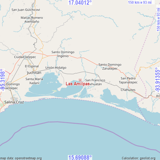
Las Amilpas GPS coordinates[2]
16° 22' 0.012" North, 94° 37' 0.012" West
| Map corner | latitude | longitude |
|---|---|---|
| Upper-left | 17.04012°, | -95.3198° |
| Center: | 16.36667°, | -94.61667° |
| Lower-right: | 15.69088°, | -93.91355° |
| Map W x H: | 150×150 km | = 93.2×93.2mi |
| max Lat: | 32.7° ⇑95.2% North |
| Las Amilpas: | 16.36667° |
| min Lat: | ⇓4.8% South 14.53588° |
| min Long | Las Amilpas | max Long |
| -117.105° | -94.61667° | -86.73105° |
| W 85.3%⇐ | ⇒14.7% E |
Elevation
Elevation of Las Amilpas is 2 m = 7 ft, and this is 1251.7 m = 4107 ft below average elevation for this country.
| Max E: |
3497 m = 11473 ft | 99.9% |
| Avg. | 1253.7 m = 4113 ft | |
| Las Amilpas | 2 m = 7 ft | |
Min E: |
-1 m = -3 ft | 0.1% |
See also: Mexico elevation on elevation.city.
Geographical zone
Las Amilpas is located in North Torrid zone (between Equator and Tropic of Cancer). Distance of this Northern Tropic circle is 786.1 km =488.5 mi to North.| Distance of | km | miles | from Las Amilpas |
|---|---|---|---|
| North Pole | 8187.3 | 5087.4 | to North |
| Arctic Circle | 5581.4 | 3468.1 | to North |
| Tropic Cancer | 786.1 | 488.5 | to North |
| Equator | 1819.8 | 1130.8 | to South |


Nearby cities:
15 places around Las Amilpas: (largest is in red/bold)
• 20 de Noviembre (El Morro)
16.9 km =10.5 mi,  120°
120°
• Cerro Grande
13.6 km =8.5 mi,  139°
139°
• Chicapa de Castro
23.3 km =14.5 mi,  290°
290°
• Guamúchil
5.6 km =3.5 mi,  273°
273°
• Huanacastal
19.9 km =12.4 mi,  52°
52°
• La Blanca
26.6 km =16.5 mi,  342°
342°
• Niltepec
21.9 km =13.6 mi,  0°
0°
• Reforma de Pineda
17.4 km =10.8 mi,  77°
77°
• San Dionisio del Mar
15.8 km =9.8 mi,  252°
252°
• San Francisco Ixhuatan
14.3 km =8.9 mi,  96°
96°
• San Francisco del Mar
11.2 km =7 mi,  105°
105°
• San Francisco del Mar Viejo
15.1 km =9.4 mi,  186°
186°
• Santa Rita (Santa Rita del Mar)
13.7 km =8.5 mi,  133°
133°
• Unión Hidalgo
25.6 km =15.9 mi,  297°
297°
• Yerba Santa
28 km =17.4 mi,  93°
93°
Sources, notices
• [Note1] Compared only with cities in Mexico existing in our database
• [Src1] Map data: © OpenStreetMap contributors (CC-BY-SA)
• [Src2] Other city data from geonames.org with taken over terms of usage.
• [Src3] Geographical zone / Annual Mean Temperature by Robert A. Rohde @ Wikipedia
