Cerro Grande geodata
Cerro Grande (Oaxaca) is a populated place; located in Mexico in America/Mexico_City (GMT-6) time zone. With population of 548 people, there are 15532 cities with bigger population in this country. Compared to other cities in Mexico, 95.9% of cities are located further ↑North; 85.4% of cities are located further ←West and 98.1% of cities have higher elevation than Cerro Grande. Note1


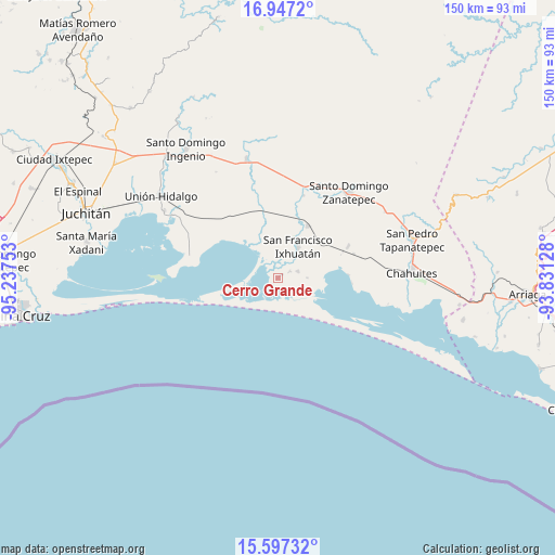
Cerro Grande GPS coordinates[2]
16° 16' 24.312" North, 94° 32' 3.84" West
| Map corner | latitude | longitude |
|---|---|---|
| Upper-left | 16.9472°, | -95.23753° |
| Center: | 16.27342°, | -94.5344° |
| Lower-right: | 15.59732°, | -93.83128° |
| Map W x H: | 150.1×150.1 km | = 93.3×93.3mi |
| max Lat: | 32.7° ⇑95.9% North |
| Cerro Grande: | 16.27342° |
| min Lat: | ⇓4.1% South 14.53588° |
| min Long | Cerro Grande | max Long |
| -117.105° | -94.5344° | -86.73105° |
| W 85.4%⇐ | ⇒14.6% E |
Elevation
Elevation of Cerro Grande is 8 m = 26 ft, and this is 1245.7 m = 4087 ft below average elevation for this country.
| Max E: |
3497 m = 11473 ft | 98.1% |
| Avg. | 1253.7 m = 4113 ft | |
| Cerro Grande | 8 m = 26 ft | |
Min E: |
-1 m = -3 ft | 1.9% |
See also: Mexico elevation on elevation.city.
Geographical zone
Cerro Grande is located in North Torrid zone (between Equator and Tropic of Cancer). Distance of this Northern Tropic circle is 796.5 km =494.9 mi to North.| Distance of | km | miles | from Cerro Grande |
|---|---|---|---|
| North Pole | 8197.6 | 5093.8 | to North |
| Arctic Circle | 5591.7 | 3474.5 | to North |
| Tropic Cancer | 796.5 | 494.9 | to North |
| Equator | 1809.4 | 1124.3 | to South |


Nearby cities:
15 places around Cerro Grande: (largest is in red/bold)
• 20 de Noviembre (El Morro)
6 km =3.7 mi,  72°
72°
• Guamúchil
17.9 km =11.1 mi,  306°
306°
• Huanacastal
23.5 km =14.6 mi,  17°
17°
• Las Amilpas
13.6 km =8.5 mi,  319°
319°
• Niltepec
33.4 km =20.8 mi,  345°
345°
• Pesquería Rancho Salinas
30.5 km =19 mi,  104°
104°
• Reforma de Pineda
16.4 km =10.2 mi,  29°
29°
• Rincón de Juárez
19.2 km =11.9 mi,  87°
87°
• San Dionisio del Mar
24.5 km =15.2 mi,  283°
283°
• San Francisco Ixhuatan
10.2 km =6.3 mi, 31°
• San Francisco del Mar
7.7 km =4.8 mi, 15°
• San Francisco del Mar Viejo
11.5 km =7.1 mi,  246°
246°
• Santa Rita (Santa Rita del Mar)
1.5 km =0.9 mi,  50°
50°
• Santo Domingo Zanatepec
30.7 km =19.1 mi,  40°
40°
• Yerba Santa
21 km =13 mi, 65°
Sources, notices
• [Note1] Compared only with cities in Mexico existing in our database
• [Src1] Map data: © OpenStreetMap contributors (CC-BY-SA)
• [Src2] Other city data from geonames.org with taken over terms of usage.
• [Src3] Geographical zone / Annual Mean Temperature by Robert A. Rohde @ Wikipedia
