San Salvador geodata
San Salvador (Hidalgo) is a seat of a second-order administrative division; located in Mexico in America/Mexico_City (GMT-6) time zone. With population of 1,070 people, there are 8156 cities with bigger population in this country. Compared to other cities in Mexico, 63.2% of cities are located further ↓South; 50.1% of cities are located further →East and 71.1% of cities have lower elevation than San Salvador. Note1


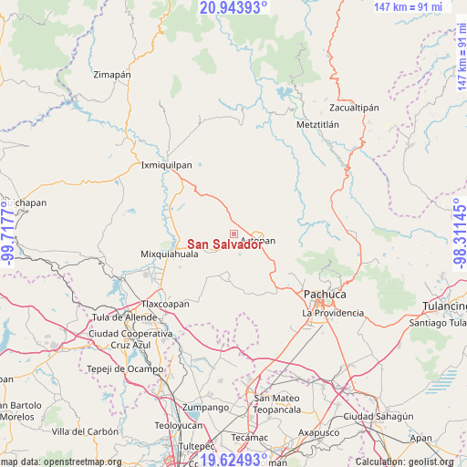
San Salvador GPS coordinates[2]
20° 17' 8.988" North, 99° 0' 52.452" West
| Map corner | latitude | longitude |
|---|---|---|
| Upper-left | 20.94393°, | -99.7177° |
| Center: | 20.28583°, | -99.01457° |
| Lower-right: | 19.62493°, | -98.31145° |
| Map W x H: | 146.7×146.7 km | = 91.2×91.2mi |
| max Lat: | 32.7° ⇑36.8% North |
| San Salvador: | 20.28583° |
| min Lat: | ⇓63.2% South 14.53588° |
| min Long | San Salvador | max Long |
| -117.105° | -99.01457° | -86.73105° |
| W 49.9%⇐ | ⇒50.1% E |
Elevation
Elevation of San Salvador is 1949 m = 6394 ft, and this is 695.3 m = 2281 ft above average elevation for this country.
| Max E: |
3497 m = 11473 ft | 28.9% |
| San Salvador | 1949 m 6394 ft | |
| Avg. | 1253.7 m = 4113 ft | |
Min E: |
-1 m = -3 ft | 71.1% |
See also: Mexico elevation on elevation.city.
Geographical zone
San Salvador is located in North Torrid zone (between Equator and Tropic of Cancer). Distance of this Northern Tropic circle is 350.3 km =217.7 mi to North.| Distance of | km | miles | from San Salvador |
|---|---|---|---|
| North Pole | 7751.5 | 4816.6 | to North |
| Arctic Circle | 5145.6 | 3197.3 | to North |
| Tropic Cancer | 350.3 | 217.7 | to North |
| Equator | 2255.6 | 1401.6 | to South |


Nearby cities:
15 places around San Salvador: (largest is in red/bold)
• Bocaja
1.8 km =1.1 mi,  162°
162°
• Bominthza
2.5 km =1.6 mi,  12°
12°
• Caxuxi
3.3 km =2.1 mi,  49°
49°
• Cañada Grande
3.4 km =2.1 mi, 14°
• Daxtha
3.7 km =2.3 mi,  100°
100°
• Demacú
2.7 km =1.7 mi,  322°
322°
• Déxtho de Victoria
4.5 km =2.8 mi,  347°
347°
• El Bondho
1 km =0.6 mi,  91°
91°
• El Olvera
2.1 km =1.3 mi,  213°
213°
• El Rosario
4.3 km =2.7 mi,  195°
195°
• Pacheco
4.6 km =2.9 mi,  237°
237°
• Poxindeje de Morelos
2.7 km =1.7 mi,  134°
134°
• San Antonio Zaragoza
3.8 km =2.4 mi,  153°
153°
• San Miguel Acambay
4.4 km =2.7 mi,  256°
256°
• Vixtha de Madero
2.9 km =1.8 mi, 242°
Sources, notices
• [Note1] Compared only with cities in Mexico existing in our database
• [Src1] Map data: © OpenStreetMap contributors (CC-BY-SA)
• [Src2] Other city data from geonames.org with taken over terms of usage.
• [Src3] Geographical zone / Annual Mean Temperature by Robert A. Rohde @ Wikipedia
