El Bondho geodata
El Bondho (Hidalgo) is a populated place; located in Mexico in America/Mexico_City (GMT-6) time zone. With population of 716 people, there are 12166 cities with bigger population in this country. Compared to other cities in Mexico, 63.2% of cities are located further ↓South; 50.1% of cities are located further ←West and 71.3% of cities have lower elevation than El Bondho. Note1


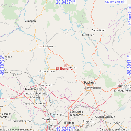
El Bondho GPS coordinates[2]
20° 17' 8.196" North, 99° 0' 17.388" West
| Map corner | latitude | longitude |
|---|---|---|
| Upper-left | 20.94371°, | -99.70796° |
| Center: | 20.28561°, | -99.00483° |
| Lower-right: | 19.62471°, | -98.30171° |
| Map W x H: | 146.7×146.7 km | = 91.2×91.2mi |
| max Lat: | 32.7° ⇑36.8% North |
| El Bondho: | 20.28561° |
| min Lat: | ⇓63.2% South 14.53588° |
| min Long | El Bondho | max Long |
| -117.105° | -99.00483° | -86.73105° |
| W 50.1%⇐ | ⇒49.9% E |
Elevation
Elevation of El Bondho is 1951 m = 6401 ft, and this is 697.3 m = 2288 ft above average elevation for this country.
| Max E: |
3497 m = 11473 ft | 28.7% |
| El Bondho | 1951 m 6401 ft | |
| Avg. | 1253.7 m = 4113 ft | |
Min E: |
-1 m = -3 ft | 71.3% |
See also: Mexico elevation on elevation.city.
Geographical zone
El Bondho is located in North Torrid zone (between Equator and Tropic of Cancer). Distance of this Northern Tropic circle is 350.4 km =217.7 mi to North.| Distance of | km | miles | from El Bondho |
|---|---|---|---|
| North Pole | 7751.5 | 4816.6 | to North |
| Arctic Circle | 5145.6 | 3197.3 | to North |
| Tropic Cancer | 350.4 | 217.7 | to North |
| Equator | 2255.5 | 1401.5 | to South |


Nearby cities:
15 places around El Bondho: (largest is in red/bold)
• Bocaja
1.8 km =1.1 mi,  194°
194°
• Bominthza
2.5 km =1.6 mi,  349°
349°
• Casa Blanca
4.9 km =3 mi,  161°
161°
• Caxuxi
2.6 km =1.6 mi,  34°
34°
• Cañada Grande
3.3 km =2.1 mi,  357°
357°
• Daxtha
2.7 km =1.7 mi,  103°
103°
• Demacú
3.4 km =2.1 mi,  309°
309°
• Déxtho de Victoria
4.8 km =3 mi,  335°
335°
• El Boxtha
4.3 km =2.7 mi,  131°
131°
• El Olvera
2.8 km =1.7 mi,  231°
231°
• El Rosario
4.7 km =2.9 mi,  207°
207°
• Poxindeje de Morelos
2 km =1.2 mi,  153°
153°
• San Antonio Zaragoza
3.5 km =2.2 mi,  168°
168°
• San Salvador
1 km =0.6 mi,  271°
271°
• Vixtha de Madero
3.9 km =2.4 mi,  249°
249°
Sources, notices
• [Note1] Compared only with cities in Mexico existing in our database
• [Src1] Map data: © OpenStreetMap contributors (CC-BY-SA)
• [Src2] Other city data from geonames.org with taken over terms of usage.
• [Src3] Geographical zone / Annual Mean Temperature by Robert A. Rohde @ Wikipedia
