Laguna Guerrero geodata
Laguna Guerrero (Quintana Roo) is a populated place; located in Mexico in America/Cancun (GMT-5) time zone. With population of 654 people, there are 13268 cities with bigger population in this country. Compared to other cities in Mexico, 70.3% of cities are located further ↑North; 99.5% of cities are located further ←West and 98.1% of cities have higher elevation than Laguna Guerrero. Note1


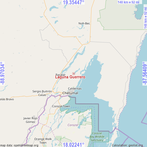
Laguna Guerrero GPS coordinates[2]
18° 41' 23.1" North, 88° 16' 1.956" West
| Map corner | latitude | longitude |
|---|---|---|
| Upper-left | 19.35447°, | -88.97034° |
| Center: | 18.68975°, | -88.26721° |
| Lower-right: | 18.02241°, | -87.56409° |
| Map W x H: | 148.1×148.1 km | = 92×92mi |
| max Lat: | 32.7° ⇑70.3% North |
| Laguna Guerrero: | 18.68975° |
| min Lat: | ⇓29.7% South 14.53588° |
| min Long | Laguna Guerrero | max Long |
| -117.105° | -88.26721° | -86.73105° |
| W 99.5%⇐ | ⇒0.5% E |
Elevation
Elevation of Laguna Guerrero is 8 m = 26 ft, and this is 1245.7 m = 4087 ft below average elevation for this country.
| Max E: |
3497 m = 11473 ft | 98.1% |
| Avg. | 1253.7 m = 4113 ft | |
| Laguna Guerrero | 8 m = 26 ft | |
Min E: |
-1 m = -3 ft | 1.9% |
See also: Mexico elevation on elevation.city.
Geographical zone
Laguna Guerrero is located in North Torrid zone (between Equator and Tropic of Cancer). Distance of this Northern Tropic circle is 527.8 km =328 mi to North.| Distance of | km | miles | from Laguna Guerrero |
|---|---|---|---|
| North Pole | 7929 | 4926.9 | to North |
| Arctic Circle | 5323.1 | 3307.6 | to North |
| Tropic Cancer | 527.8 | 328 | to North |
| Equator | 2078.1 | 1291.3 | to South |


Nearby cities:
15 places around Laguna Guerrero: (largest is in red/bold)
• Bacalar
13.3 km =8.3 mi,  265°
265°
• Calderitas
15 km =9.3 mi,  175°
175°
• Carlos A. Madrazo
34.3 km =21.3 mi,  232°
232°
• Chetumal
19.9 km =12.4 mi,  191°
191°
• Huay-Pix
25.5 km =15.8 mi,  221°
221°
• Juan Sarabia
30.8 km =19.1 mi, 226°
• Luis Echeverría Álvarez
6.3 km =3.9 mi,  125°
125°
• Maya Balam
31 km =19.3 mi,  333°
333°
• Miguel Hidalgo y Costilla
17.9 km =11.1 mi, 333°
• Reforma
34.9 km =21.7 mi,  293°
293°
• Salamanca
21.7 km =13.5 mi, 265°
• San Isidro la Laguna
17.4 km =10.8 mi,  321°
321°
• Subteniente López
25.3 km =15.7 mi,  211°
211°
• Ucum
33.7 km =20.9 mi, 231°
• Xul-Ha
25.8 km =16 mi, 233°
Sources, notices
• [Note1] Compared only with cities in Mexico existing in our database
• [Src1] Map data: © OpenStreetMap contributors (CC-BY-SA)
• [Src2] Other city data from geonames.org with taken over terms of usage.
• [Src3] Geographical zone / Annual Mean Temperature by Robert A. Rohde @ Wikipedia
