Huay-Pix geodata
Huay-Pix (Quintana Roo) is a populated place; located in Mexico in America/Cancun (GMT-5) time zone. With population of 1,649 people, there are 5260 cities with bigger population in this country. Compared to other cities in Mexico, 72.4% of cities are located further ↑North; 99.3% of cities are located further ←West and 99.6% of cities have higher elevation than Huay-Pix. Note1


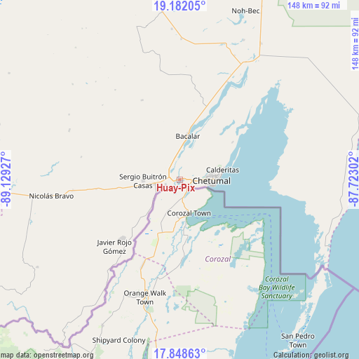
Huay-Pix GPS coordinates[2]
18° 30' 59.904" North, 88° 25' 34.104" West
| Map corner | latitude | longitude |
|---|---|---|
| Upper-left | 19.18205°, | -89.12927° |
| Center: | 18.51664°, | -88.42614° |
| Lower-right: | 17.84863°, | -87.72302° |
| Map W x H: | 148.3×148.3 km | = 92.1×92.1mi |
| max Lat: | 32.7° ⇑72.4% North |
| Huay-Pix: | 18.51664° |
| min Lat: | ⇓27.6% South 14.53588° |
| min Long | Huay-Pix | max Long |
| -117.105° | -88.42614° | -86.73105° |
| W 99.3%⇐ | ⇒0.7% E |
Elevation
Elevation of Huay-Pix is 4 m = 13 ft, and this is 1249.7 m = 4100 ft below average elevation for this country.
| Max E: |
3497 m = 11473 ft | 99.6% |
| Avg. | 1253.7 m = 4113 ft | |
| Huay-Pix | 4 m = 13 ft | |
Min E: |
-1 m = -3 ft | 0.4% |
See also: Mexico elevation on elevation.city.
Geographical zone
Huay-Pix is located in North Torrid zone (between Equator and Tropic of Cancer). Distance of this Northern Tropic circle is 547.1 km =340 mi to North.| Distance of | km | miles | from Huay-Pix |
|---|---|---|---|
| North Pole | 7948.2 | 4938.8 | to North |
| Arctic Circle | 5342.3 | 3319.6 | to North |
| Tropic Cancer | 547.1 | 340 | to North |
| Equator | 2058.9 | 1279.3 | to South |


Nearby cities:
15 places around Huay-Pix: (largest is in red/bold)
• Allende
20.1 km =12.5 mi,  222°
222°
• Bacalar
18.6 km =11.6 mi,  10°
10°
• Calderitas
18.5 km =11.5 mi,  76°
76°
• Carlos A. Madrazo
10.6 km =6.6 mi,  260°
260°
• Chetumal
12.9 km =8 mi,  91°
91°
• Juan Sarabia
6 km =3.7 mi,  252°
252°
• Palmar
13.4 km =8.3 mi,  235°
235°
• Ramonal
15.6 km =9.7 mi,  226°
226°
• Sabidos
24.6 km =15.3 mi, 223°
• Sacxán
11.3 km =7 mi, 239°
• Salamanca
18.2 km =11.3 mi,  344°
344°
• Sergio Butrón Casas
15 km =9.3 mi,  268°
268°
• Subteniente López
4.4 km =2.7 mi,  122°
122°
• Ucum
9.8 km =6.1 mi, 260°
• Xul-Ha
5.5 km =3.4 mi,  314°
314°
Sources, notices
• [Note1] Compared only with cities in Mexico existing in our database
• [Src1] Map data: © OpenStreetMap contributors (CC-BY-SA)
• [Src2] Other city data from geonames.org with taken over terms of usage.
• [Src3] Geographical zone / Annual Mean Temperature by Robert A. Rohde @ Wikipedia
