Monte Ordóñez geodata
Monte Ordóñez (Chiapas) is a populated place; located in Mexico in America/Mexico_City (GMT-6) time zone. With population of 519 people, there are 16226 cities with bigger population in this country. Compared to other cities in Mexico, 98.4% of cities are located further ↑North; 94.4% of cities are located further ←West and 51.1% of cities have lower elevation than Monte Ordóñez. Note1


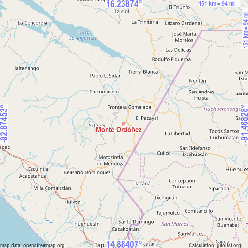
Monte Ordóñez GPS coordinates[2]
15° 33' 45.072" North, 92° 10' 17.04" West
| Map corner | latitude | longitude |
|---|---|---|
| Upper-left | 16.23874°, | -92.87453° |
| Center: | 15.56252°, | -92.1714° |
| Lower-right: | 14.88407°, | -91.46828° |
| Map W x H: | 150.6×150.6 km | = 93.6×93.6mi |
| max Lat: | 32.7° ⇑98.4% North |
| Monte Ordóñez: | 15.56252° |
| min Lat: | ⇓1.6% South 14.53588° |
| min Long | Monte Ordóñez | max Long |
| -117.105° | -92.1714° | -86.73105° |
| W 94.4%⇐ | ⇒5.6% E |
Elevation
Elevation of Monte Ordóñez is 1487 m = 4879 ft, and this is 233.3 m = 765 ft above average elevation for this country.
| Max E: |
3497 m = 11473 ft | 48.9% |
| Monte Ordóñez | 1487 m 4879 ft | |
| Avg. | 1253.7 m = 4113 ft | |
Min E: |
-1 m = -3 ft | 51.1% |
See also: Mexico elevation on elevation.city.
Geographical zone
Monte Ordóñez is located in North Torrid zone (between Equator and Tropic of Cancer). Distance of this Northern Tropic circle is 875.5 km =544 mi to North.| Distance of | km | miles | from Monte Ordóñez |
|---|---|---|---|
| North Pole | 8276.7 | 5142.9 | to North |
| Arctic Circle | 5670.8 | 3523.7 | to North |
| Tropic Cancer | 875.5 | 544 | to North |
| Equator | 1730.4 | 1075.2 | to South |


Nearby cities:
15 places around Monte Ordóñez: (largest is in red/bold)
• Agua Zarca
8.5 km =5.3 mi,  19°
19°
• Bella Vista
8.4 km =5.2 mi,  286°
286°
• El Progreso
5.6 km =3.5 mi,  299°
299°
• El Triunfo de las Tres Maravillas
9.5 km =5.9 mi,  9°
9°
• La Grandeza
8.2 km =5.1 mi,  225°
225°
• La Montaña
2.1 km =1.3 mi, 302°
• Miguel Hidalgo
9.7 km =6 mi,  124°
124°
• Nueva Morelia
6.8 km =4.2 mi, 24°
• Nuevo Amatenango
8.9 km =5.5 mi,  132°
132°
• Ojo de Agua Centro
7.2 km =4.5 mi,  181°
181°
• Ojo de Agua Grande
8.1 km =5 mi,  173°
173°
• Pacayalito
9.2 km =5.7 mi,  66°
66°
• Reforma
6.2 km =3.9 mi, 121°
• Río Guerrero
2.8 km =1.7 mi,  32°
32°
• Unión Progreso
6.7 km =4.2 mi, 293°
Sources, notices
• [Note1] Compared only with cities in Mexico existing in our database
• [Src1] Map data: © OpenStreetMap contributors (CC-BY-SA)
• [Src2] Other city data from geonames.org with taken over terms of usage.
• [Src3] Geographical zone / Annual Mean Temperature by Robert A. Rohde @ Wikipedia
